
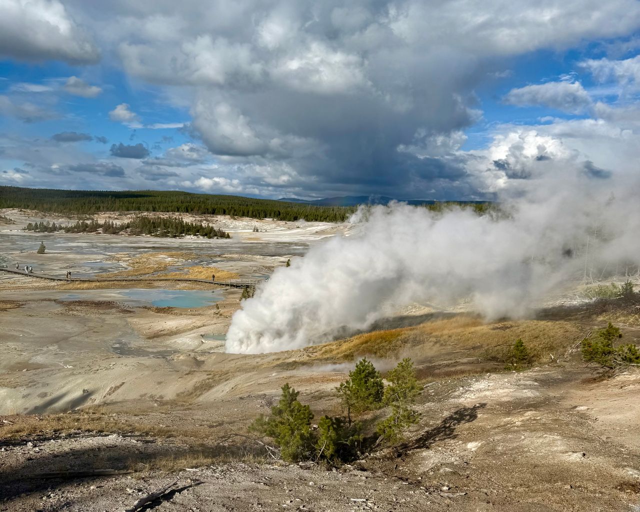
Yellowstone earns its status as America’s first national park in ways that become obvious within a day of arriving — ancient geologic formations, the largest concentration of geysers on the planet, herds of bison sharing the road with your car, and a landscape genuinely unlike anywhere else in the country because much of it sits directly above one of the largest active volcanic systems on Earth. Most visitors know Old Faithful. Far fewer know that the park contains over a thousand miles of trail, ranging from wheelchair-accessible boardwalks over bubbling mud pots to genuinely strenuous mountain hikes with wildflower-covered switchbacks and panoramic Teton views.
This guide covers the best hikes in Yellowstone, organized from the easiest boardwalk strolls through the park’s most impressive strenuous options — with current 2026 entrance fee information, seasonal considerations, and the practical details that make the difference between a rushed drive-by visit and genuinely experiencing what makes this park singular.
For gear to prepare for any of these hikes, our day hiking essentials checklist covers the basics, and our best hikes in Grand Teton National Park guide covers the neighboring park most Yellowstone visitors combine into the same trip.
Before You Go — Essential 2026 Planning Information
Entrance fees and no reservation system. Yellowstone charges $35 per private vehicle for a 7-day pass, $30 for motorcycles or snowmobiles, and $20 per person entering on foot, bicycle, or skis; all five entrance stations accept both cash and credit or debit, unlike several other major parks that have gone cashless. Unlike Glacier or several other high-traffic parks, Yellowstone has no timed-entry or vehicle reservation system in 2026 — you only need a standard entrance pass, purchasable in advance on Recreation.gov or directly at any entrance station.
International visitor surcharge. As of January 1, 2026, non-U.S. residents aged 16 and older pay an additional $100 surcharge on top of the standard entrance fee, part of a broader Interior Department policy affecting Yellowstone and several of the most-visited national parks. This surcharge is waived for visitors holding a valid Yellowstone Annual Pass or America the Beautiful Pass.
Road opening and closure dates. Yellowstone’s roads open in stages between mid-April and late May depending on snowpack, with high mountain passes typically closing in mid-October and most park roads closing for the season by late October. Check current road status before planning any itinerary that depends on reaching a specific area of the park.
Elevation matters throughout the park. Yellowstone sits above 7,000 feet across most of its developed areas, and several trails on this list climb well above that. Visitors arriving from lower elevations should expect reduced exertion capacity initially, especially on the park’s more strenuous hikes.
Wildlife safety and seasonal trail closures. Trails throughout Yellowstone are subject to seasonal closure due to bear activity, particularly during summer months — check current trail status before heading out. Never approach wildlife, including bison grazing near roads or trails; the park enforces legal minimum distances, and violations are both dangerous and illegal. Bison in particular cause more visitor injuries in Yellowstone than any other animal.
Wildfire smoke is a real seasonal consideration. Depending on the year, wildfire smoke from fires burning elsewhere in the West can drift into the park, particularly in late summer, reducing visibility and air quality even on an otherwise clear day. Check regional air quality conditions if you’re visiting during peak fire season.
Easy Hikes — Boardwalks and Accessible Trails
Grand Prismatic Overlook Trail — Best Short Hike in the Park
Distance: 1.2 miles round trip | Elevation gain: 105 feet | Difficulty: Easy
This trail delivers what is consistently described as one of the most surprisingly beautiful vistas in any national park, for remarkably little physical effort. Starting at the Fairy Falls Trailhead — where parking is genuinely limited and fills quickly in peak season — the trail climbs gently to an elevated platform overlooking Grand Prismatic Spring, the largest hot spring in the United States, and the surrounding Midway Geyser Basin. The rainbow-colored spring, visible from directly above rather than at ground level, is the single most photographed feature in the park for good reason — the overlook perspective reveals the full scale and color gradient of the spring in a way the boardwalk at ground level simply can’t match.
Most visitors pair this hike with a walk on the Midway Geyser Basin boardwalk to see the spring up close at ground level as well — the two perspectives are genuinely complementary rather than redundant. The overlook trail itself was specifically constructed by the park’s trail crew using fee revenue, after resource damage and visitor safety concerns from off-trail scrambling on the surrounding hills became a real problem.
Practical tip: Arrive early. The Fairy Falls parking lot is small and this has become one of the most popular short hikes in the entire park.
Mud Volcano Trail — Best Easy Introduction to Thermal Features
Distance: Roughly 0.6 miles (loop) | Elevation gain: Minimal to 200 feet depending on route | Difficulty: Easy
Located southeast of Canyon Village, this boardwalk loop introduces visitors to some of the park’s most acidic and visually unusual thermal features in a short, accessible walk. The trail’s namesake mud volcano is genuinely striking despite — or perhaps because of — the strong sulfuric smell that comes with it, and Dragon’s Mouth Spring is a particular highlight: a cave-like opening releasing visible steam and a deep, resonant gurgling sound that visitors consistently describe as genuinely eerie in the best way.
Other named features along the loop, including Sour Lake and Sizzling Cauldron, round out a walk through some of the most concentrated acidic thermal activity in the park. The smell is real and worth expecting in advance — sulfuric gases rising from the ground are not dangerous to visit, but they’re distinctly unpleasant, and knowing that ahead of time prevents the surprise from overshadowing what is otherwise a genuinely fascinating short walk.
Practical tip: This is an excellent stop for understanding Yellowstone’s broader geology — the entire park sits above the Yellowstone hotspot, where magma close to the surface heats groundwater and creates the geysers, hot springs, and mud pots found throughout the park. Geologists studying the system say a major eruption in the next several hundred years remains unlikely.
West Thumb Geyser Basin — Best Combination of Geothermal Features and Lake Views
Distance: Roughly 0.75 miles (two connected loops) | Elevation gain: Minimal | Difficulty: Easy
This boardwalk trail delivers a genuinely distinctive combination that few other short hikes in the park match — a geothermal basin sitting directly beside Yellowstone Lake, the largest high-elevation lake in North America at 7,700 feet above sea level and covering 136 square miles. The juxtaposition of steaming, colorful thermal features against the calm blue expanse of the lake is visually striking in a way that photographs consistently undersell.
A quirky highlight along the route is the Fishing Cone, a small geothermal feature sitting right at the lake’s edge where early visitors reportedly caught fish in the lake and cooked them directly in the geothermal cone without ever moving from one spot — a practice no longer permitted but still a genuinely fun piece of trail trivia. The lake itself holds the largest population of native cutthroat trout in North America, a population that has puzzled scientists for decades given that the lake drains toward the Atlantic with no connecting waterway to the Pacific, where the species originated.
Porcelain Basin and Back Basin Trails (Norris Geyser Basin) — Best Peaceful Double Loop
Distance: Roughly 1 mile plus 1.75 miles (combined) | Elevation gain: Minimal | Difficulty: Easy
These two connected trails in the Norris area are frequently recommended as a pair — the shorter Porcelain Basin loop connects directly to the longer Back Basin Trail, and together they cover ground that’s described as both relaxing and genuinely informative without demanding much physical effort. Most of the walking is on boardwalk or well-maintained path, occasionally with stairs, making this one of the more accessible multi-feature areas in the park.
The Back Basin includes Steamboat Geyser, the tallest active geyser in the world — when it erupts, water can shoot several hundred feet into the air. The catch is genuine unpredictability: eruptions have historically occurred anywhere from weeks to, in rare cases, decades apart, so don’t plan a visit specifically hoping to witness one. Visit for the peaceful, varied thermal scenery along both loops, and treat a Steamboat eruption as a rare bonus rather than an expectation.
Fountain Paint Pot Trail — Best for Seeing All Four Thermal Feature Types
Distance: Roughly 0.5 miles | Elevation gain: Minimal | Difficulty: Easy
This short boardwalk loop is genuinely distinctive among Yellowstone’s short hikes because it’s the one trail where visitors can see all four types of the park’s geothermal features in a single short walk — hot springs, mud pots, geysers, and fumaroles, each represented along the route. For visitors curious about the actual geological distinctions between these features rather than just admiring them, this trail provides the most efficient single-stop education in the park.
The mud pots here are a particular highlight — genuinely different in character from the calmer thermal features found elsewhere, with visibly bubbling, viscous mud that shifts and pops as gas escapes from below.
Moderate Hikes
Artist Point — Best Quick Stop for a Spectacular View
Distance: Roughly 0.25 miles from the parking area | Elevation gain: Minimal | Difficulty: Easy
Calling Artist Point a hike is something of an overstatement — it’s a short walk from the parking lot to a series of viewing platforms — but the view itself belongs on any list of the park’s essential stops. Overlooking the Grand Canyon of the Yellowstone and the Lower Falls, the vista here is frequently cited by repeat national park visitors as among the finest they’ve encountered anywhere in the park system, distinctive specifically because nowhere else combines a canyon this dramatic with a waterfall this powerful in quite the same composition. The name comes honestly: this exact view has attracted painters for generations, drawn by the same qualities of light and color that make it a magnet for photographers today.
North Rim Trail to Lookout Point — Best Waterfall Views for Moderate Effort
Distance: As short as 0.15 miles round trip to Lookout Point itself, longer with the side trail down toward the canyon | Elevation gain: As little as 25 feet at Lookout Point, considerably more via the side descent | Difficulty: Easy to Moderate depending on route
The Grand Canyon of the Yellowstone contains three major waterfalls along the Yellowstone River, and the Lower Falls — dropping 308 feet as the river rushes through a massive volume of water — is the largest and most dramatic of the three. Several trails provide access to views of the falls, including the Brink of the Lower Falls Trail, but Lookout Point is the option most commonly recommended for the majority of visitors: a very short, very accessible trail with minimal elevation change that still delivers a genuinely excellent view of both the canyon and the falls.
For hikers willing to do more, a side trail descends from Lookout Point down into the canyon itself via a series of switchbacks, delivering an even more dramatic, unobstructed view of the Lower Falls from a considerably lower vantage point. This descent is meaningfully more strenuous than the main trail, and worth factoring the return climb into your planning — remember that Yellowstone sits above 7,000 feet, so any climbing here demands more from unacclimatized lungs than the same elevation gain would at sea level.
Upper Geyser Basin Trail — Best Trail for Seeing Multiple Major Geysers
Distance: Just under 5 miles | Elevation gain: Minimal, mostly flat wooden boardwalk | Difficulty: Moderate (due to distance rather than terrain)
Starting from Old Faithful, this trail passes through the most concentrated collection of geysers found anywhere in the world — roughly 150 geysers along a single route, each with its own character and eruption pattern. Beyond Old Faithful itself, which erupts predictably enough to be caught multiple times in a single day, the trail passes several other major geysers worth timing your walk around, including Grand Geyser and Riverside Geyser — both significant eruptions that draw crowds when a predicted window approaches.
Toward the end of the trail, keep an eye out for a distinctive rock and mineral formation that many visitors have nicknamed for its uncanny resemblance to a creature emerging from the ground, complete with what looks like eyes, a nose, and a hand — a fun bit of pattern recognition that adds a lighter moment to an otherwise scientifically fascinating walk. Despite the flat, mostly boardwalk terrain, the nearly 5-mile distance and the genuinely large number of stops worth pausing at make this a longer commitment than the short thermal-basin walks elsewhere on this list — budget several hours to do it properly rather than rushing through.
Strenuous Hikes
Table Mountain (Idaho Side of the Tetons) — Best Strenuous Hike With Grand Teton Views
Note: This hike is technically located in the Jedediah Smith Wilderness on the Idaho side of the Teton Range, accessed via a separate route from Yellowstone proper, but it’s frequently combined into the same broader Yellowstone-and-Tetons trip and is worth including for hikers looking for a genuinely strenuous option in the region.
Access requires driving to the Idaho side of the Tetons via Ski Hill Drive toward the Grand Targhee ski resort, then turning off toward a campground trailhead. From there, hikers choose between a steep, direct route straight up the mountain’s face — faster but considerably more demanding — or the longer Huckleberry Trail, which switchbacks up more gradually. A popular approach among experienced local hikers is ascending via the steep face and descending via Huckleberry, taking advantage of the faster climb while sparing the knees on the way down.
The payoff at the summit, sometimes called Table Rock, is a direct, unobstructed view of the entire Teton Range from across the valley — widely regarded by longtime Jackson Hole locals as one of the single best hiking views in the entire region, Yellowstone included. Wildflower displays along the route add to the appeal in season, and this is consistently the hike locals recommend to visitors who want one genuinely memorable, effort-earned view during their trip.
Building Your Yellowstone Itinerary
One day: Grand Prismatic Overlook Trail in the morning, followed by the Midway Geyser Basin boardwalk at ground level, then Artist Point and Lookout Point in the Canyon area in the afternoon.
Two to three days: Day one covers the geyser basins — Upper Geyser Basin from Old Faithful, followed by Fountain Paint Pot and the Grand Prismatic Overlook. Day two covers the Canyon and Lake areas — Artist Point, Lookout Point, West Thumb Geyser Basin, and Mud Volcano. Day three covers the Norris area’s Porcelain and Back Basin trails, plus Mammoth Hot Springs in the park’s northern section.
Four or more days: Add Table Mountain as a genuinely strenuous day trip if you’re combining the visit with Grand Teton National Park, and build in a slower pace throughout — Yellowstone rewards visitors who linger at each thermal feature rather than rushing between checklist stops.
Final Thoughts
Yellowstone rewards visitors who understand that its best hikes aren’t necessarily its longest ones. A quarter-mile walk to Artist Point or a mile-long loop through the Norris Geyser Basin can deliver more genuine wonder than a demanding backcountry trek, simply because the park’s defining features — the geysers, hot springs, and canyon views — are concentrated in specific, accessible locations rather than requiring miles of remote hiking to reach. Start with the boardwalk trails to understand what makes this park’s geology so singular, add Artist Point and Lookout Point for the canyon and waterfall views that rival anywhere in the National Park System, and if you’re combining the trip with nearby Grand Teton, save a day for Table Mountain’s genuinely earned summit view.
Respect wildlife distances throughout, check trail closures for bear activity before setting out, and don’t underestimate how much the park’s 7,000-plus-foot elevation affects even modest climbs if you’re arriving from lower ground.
For more national park hiking guides, check our best hikes in Grand Teton National Park and best hikes in Glacier National Park guides.