
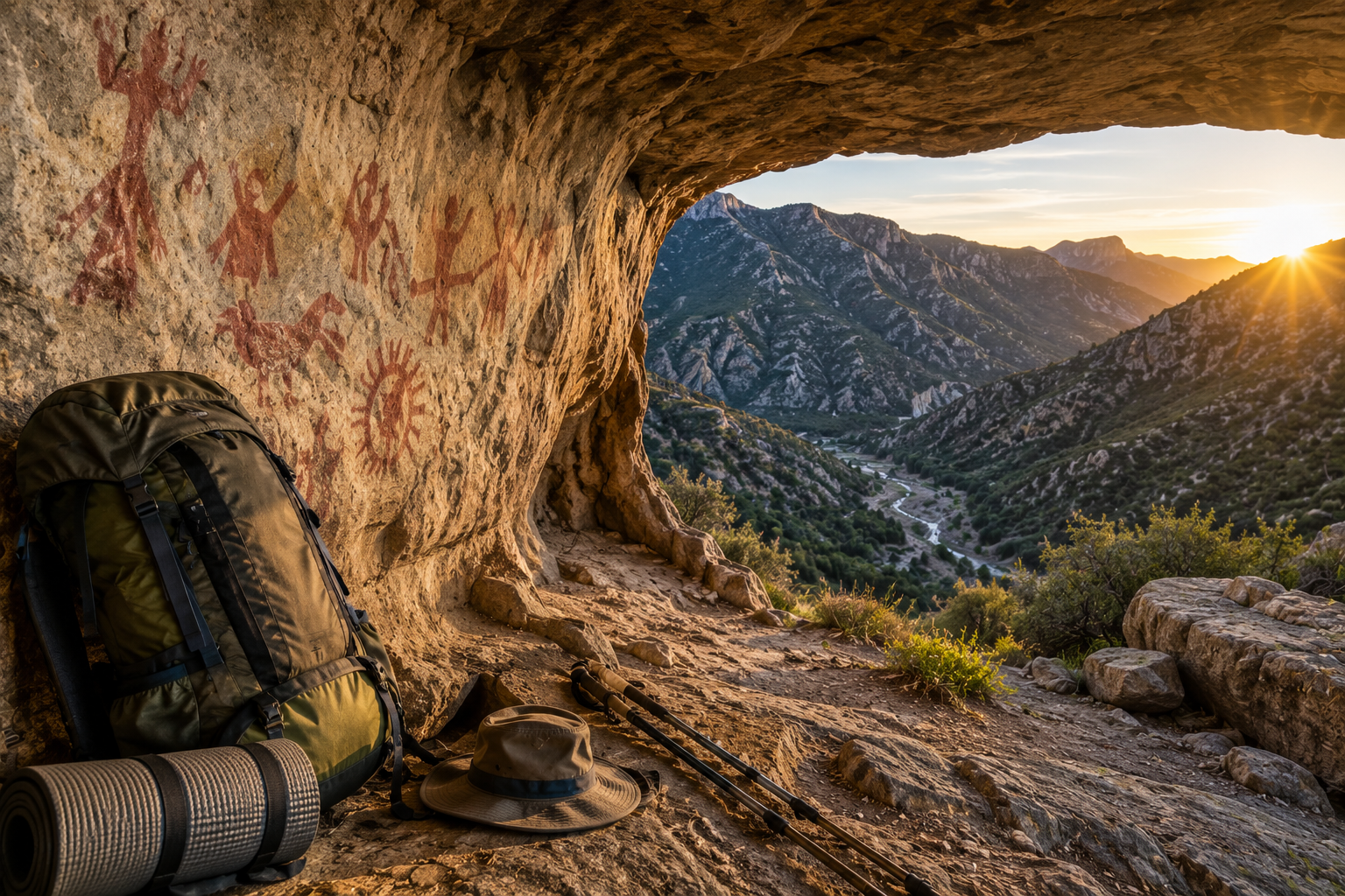
There are places in Southern California that most people don’t know exist — and that’s by design. The Sespe Wilderness in Los Padres National Forest covers some of the most rugged, remote, and genuinely wild terrain in the state, protecting a creek system that runs free without dams for 61 miles, a 53,000-acre condor sanctuary closed to the public, and a cave containing ancient Chumash pictographs that fewer than ten people visited in the years since 2022.
The Alder Creek Cave and its Chumash rock art is one of the most significant and least-visited archaeological sites in Southern California. The pictographs — painted by the Ventureño Chumash people who inhabited this region for thousands of years — span the full face of a rock shelter deep in the Alder Creek drainage. Getting there requires genuine backcountry navigation skill, multiple creek crossings, serious brush, and a multi-day commitment that filters out casual visitors as effectively as any permit system.
This guide covers everything you need to plan a Sespe Wilderness backpacking trip to the Alder Creek Cave — route logistics, trail conditions, seasonal considerations, wildlife, Leave No Trace obligations specific to this site, and what to realistically expect from one of the most demanding and rewarding multi-day routes in the Los Padres National Forest.
For gear recommendations before any of these hikes, our day hiking essentials checklist and how to pack a backpack for hiking guide cover everything worth carrying on a multi-day technical route like this one.
Overview — What You’re Getting Into
This is not a trail for inexperienced hikers. The route to Alder Creek Cave involves significant cross-country navigation without maintained trail, multiple creek crossings that vary from easy rock hops to chest-deep water crossings depending on season, dense chaparral brush in sections where trail essentially disappears, poison oak throughout the lower canyon sections, and the physical demands of multi-day backcountry travel far from any rescue access.
The reward for that commitment is proportional. You’ll travel through a California condor sanctuary where these massive birds recover from near-extinction above the canyon. You’ll cross a creek whose direction of flow was permanently reversed by a massive earthquake — one of the only places in California where the geological record of seismic activity is visible in the direction a creek runs. You’ll find Native American mortar holes worn into granite by thousands of years of food preparation. You’ll see bighorn sheep on the canyon walls if you move quietly and look carefully. And at the end of the most difficult section, you’ll enter a rock shelter where Chumash pictographs cover the full cave face — drawings made with seed oils, animal fats, and mineral pigments by people who lived in this wilderness for millennia before anyone else arrived.
The visit register at the cave has fewer than ten entries since 2022. That kind of solitude doesn’t exist at trailheads with parking lots and interpretive signs. It comes with the route-finding, the brush, the creek crossings, and the commitment.
Getting There — Trailhead Access
Johnson Ridge Trailhead / Mutau Flat: The starting point for the route described in this guide. Access via Grade Valley Road — a well-graded dirt road that takes approximately 35 minutes to drive from the highway. Standard two-wheel drive vehicles handle this road in dry conditions; check conditions after rain before attempting it.
Dough Flat Trailhead (Alternate Access): Take Highway 126 to Fillmore. Turn north on A Street/Goodenough Road and drive 14.1 miles to Dough Flat. This is a rough dirt road that is traveled by large oil trucks. Continue on to the end of the road at the Dough Flat trailhead. Sometimes the gate is locked and you have to walk an extra 5 miles to the trailhead. The Dough Flat approach accesses the Alder Creek Trail (20W11) from the south end and is the more commonly documented route in existing trip reports. Hikeup
From the Dough Flat trailhead, you enter the Sespe Wilderness and the Sespe Condor Sanctuary. The Alder Creek Trail starts from the Dough Flat trailhead — 2.5 miles north is the first trail junction. The trail to the right is the Bucksnort Trail, which ends at Ant Camp at the junction with the Agua Blanca Trail. Go left toward Alder Creek. Hikeup
Permits and Regulations: A California Campfire Permit is required for any open flame in the Los Padres National Forest, obtainable free at CAFirePermits.com. The Sespe Condor Sanctuary areas are closed to public entry — the route described here passes through the wider wilderness rather than the closed sanctuary core. Leave No Trace compliance is mandatory and enforced in this designated wilderness area.
The Route — Johnson Ridge to Alder Creek Cave
Day 1: Johnson Ridge to Little Matau Creek Canyon
The trail from the Johnson Ridge trailhead begins clearly enough — trail signage at the trailhead points the direction and the initial path is navigable. Within the first two miles the character of the route begins to assert itself. The trail descends approximately 300 feet to meet the first creek crossing at the Little Matau Creek area — a junction with significant water flow early in the season that dries substantially by late summer and fall.
An interesting geological footnote at this creek crossing: the Little Matau Creek historically flowed east to west. A major earthquake in the region reversed its flow direction permanently, and it now runs west to east. This makes it one of the only accessible locations in Southern California where the seismic history of the landscape is visible in something as fundamental as the direction water moves.
The trail continues up into the Little Matau Creek Canyon, gaining elevation toward a saddle at approximately 5,729 feet that marks the transition between the initial approach and the more technical terrain ahead. Views from this ridge expand dramatically as you gain elevation — the canyon system visible below gives a useful sense of the geography you’ll be navigating through over the following days.
The trail is overgrown in sections throughout this approach — not requiring full bushwhacking but demanding enough attention to route-finding that straying off the faint path is easy. The vegetation is dense enough that pace slows significantly compared to maintained trail hiking.
Wildlife along this approach is abundant. Quail and rabbits are common throughout. Coyotes are active in the area — their vocalizations through the night are part of the Sespe experience. The canyon system you’re entering is condor habitat, and these enormous birds are sometimes visible riding thermals above the canyon walls with their distinctive 9-foot wingspan and white underwing triangles.
Camp: The saddle at 5,729 provides a potential first-night camp with views and reasonable flat ground. Early season creek water is available below. Carry sufficient water for any dry camp above the creek level.
Day 2: Little Matau Creek Canyon to Alder Creek Cave
This is the most demanding day of the route and the one where the honest assessment of the trail’s condition becomes fully apparent. After the Little Matau Creek meets the trail in the lower canyon sections, the maintained path effectively disappears in places. What replaces it is a combination of use trail, animal tracks, creek bed travel, and cross-country navigation through brush that requires genuine backcountry skill to manage efficiently.
The creek crossings multiply in this section. Early season crossings can be waist-deep or deeper depending on snowmelt conditions — assess crossing difficulty before committing and look for the shallowest, slowest sections. Crossing and recrossing the creek to find better ground on the opposite bank is standard practice on this route. Trekking poles provide meaningful stability on creek crossings with significant current.
Poison oak is present throughout the canyon below. It is abundant enough that avoiding contact entirely requires careful route selection. Long pants and long sleeves reduce exposure significantly. Wash exposed skin and clothing as soon as possible after the hike day ends. Know how to identify it — three leaflets, waxy surface, red-tinged new growth — and avoid touching it or any gear that has contacted it.
The brush in the canyon sections is dense enough that progress slows dramatically. A mile per hour through the worst sections is realistic — factor this into your timeline and start early to avoid running the most difficult sections in fading afternoon light. Animal tracks, particularly deer trails, often provide the best route through otherwise impenetrable chaparral — they find the same least-resistance lines through the brush that experienced navigators use.
When the canyon walls close in around you and descent to the creek bed becomes unavoidable, commit to it cleanly rather than fighting the walls. The creek bed itself — when water levels allow — often provides cleaner travel than the brush-covered hillsides above it.
The Oak Tree Camp marks a significant milestone on the approach to the cave. The main attraction in this neck of the woods is the cave on the Alder — the one with numerous Chumash pictographs. The cave is located above a rock face that parallels the creek bed in the Alder Creek area. Navigation to the cave requires leaving the main drainage and exploring the rock face — look for the shelter where the overhang is deepest and the cave floor shows evidence of repeated human presence over centuries. Hiking Backpack Pro
A critical safety note on the approach: Bee and wasp nests are present in rock crevices and hollow trees throughout the canyon. Move carefully around rocky overhangs and hollow vegetation. If you disturb a nest, move away quickly and calmly in a straight line — running erratically attracts pursuit. For hikers with known severe bee allergies, carry an epinephrine auto-injector and inform your hiking partner of your allergy and the location of the device before entering the canyon.
The Alder Creek Cave and Chumash Pictographs
Created by the Chumash Indians, these complex and intriguing pictographs are found on numerous rock outcroppings and in caves throughout Los Padres National Forest. The Alder Creek Cave contains one of the more significant concentrations of this art in the Sespe Wilderness — pictographs spanning the full rock face of the shelter, from near ground level to the upper reaches of the overhang. Hike SEO
The Ventureño Chumash people who created these paintings thrived near the Pacific coast of Southern California for thousands of years. The pictographs were made using seed oils, animal fats, and mineral pigments collected from the surrounding landscape and crushed using stone mortars — some of which remain visible in the canyon as shallow circular depressions worn into granite outcrops near water sources. The mortar holes you’ll pass on the route are physical evidence of daily life in this canyon over centuries.
The paintings at this cave are more weathered than photographs from previous decades suggest — time, moisture, and the fragility of organic-based pigments means the art degrades continuously without any intervention. What’s visible now may be less visible in another generation. The color and detail that remains is remarkable given the conditions the paintings have survived.
This is a protected archaeological site. The cave and its pictographs are protected under the Archaeological Resources Protection Act, the National Historic Preservation Act, and Forest Service wilderness regulations. The specific obligations for visitors:
Do not touch the pictographs under any circumstances. Body oils from a single handprint can cause chemical damage to the pigments that accelerates degradation for decades. The damage from touching is irreversible and cumulative — each touch reduces what future visitors will be able to see.
Do not apply chalk, water, or any substance to the rock surface in an attempt to make the paintings more visible for photography. This practice causes severe damage that far exceeds the original weathering.
Do not camp within the immediate area of the cave. The fire ring and camping evidence near the cave indicates past visitors have camped here — this concentrates human impact at the most sensitive point on the entire route.
Photograph without flash. Direct flash photography at close range accelerates photochemical degradation of organic pigments.
Sign the register. The few signatures in it since 2022 provide Forest Service documentation of visitation that supports preservation efforts and management decisions for this site.
The depth of the cave extends well beyond what’s visible from the entrance — the pictographs continue into the interior. Explore only what’s accessible without climbing on the rock face or disturbing the cave floor, which may contain subsurface archaeological material.
Native American Mortar Holes
Before or after visiting the cave, the route passes several granite outcrops with mortar holes — shallow circular depressions worn into the rock surface by thousands of repetitions of the same motion: stone pestle grinding acorns, seeds, and other plant foods. These mortars were often used communally, and their presence in specific locations tells archaeologists about the seasonal movements and food processing practices of the people who lived here.
The mortar holes are also protected archaeological resources. Do not place objects in them, pour water into them for cleaning purposes, or disturb the area around them. Their value as archaeological evidence depends on their remaining in their original condition and context.
Day 3: Alder Creek to SESPE Creek and Johnson Ridge Exit
From Alder Creek, the route joins the SESPE Creek system — a transition from the most demanding cross-country travel of the trip to a more navigable canyon with trail sections that become increasingly clear as you approach the SESPE proper.
The name Sespe can be traced to a Chumash Indian village, called Cepsey, Sek-pe or S’eqpe’ meaning “Kneecap” in the Chumash language in 1791. The creek itself is one of the longest free-flowing, undammed creeks remaining in Southern California — a Wild and Scenic River designation that protects its natural character and makes it ecologically significant far beyond its role as a hiking destination. Backlinko
The climb from Alder Creek over the ridge to SESPE involves approximately 1,000 feet of ascent followed by a similar descent on the far side — the most significant elevation work of the final day. Trail signs at the SESPE junction provide the first reliable navigation markers in over 15 miles of route. The psychological effect of a trail sign after extended cross-country travel is difficult to overstate.
SESPE Hot Springs: At the junction where Johnson Ridge exits left, SESPE Hot Springs lies a short distance down the right fork. The hot springs are the most popular destination in the SESPE wilderness among hikers who access them via the shorter Pedro Blanca trailhead approach — significantly easier to reach than the multi-day route described here. For hikers who’ve spent three days navigating Alder Creek and have the energy, a hot spring soak before the final climb is a legitimate reward. For hikers who are short on water, food, or daylight, the direct exit via Johnson Ridge is the more practical choice.
Bighorn Sheep: The canyon walls above the SESPE Creek junction are one of the most reliable locations for bighorn sheep sightings in the Los Padres. These animals have recovered significantly in the Sespe Wilderness and are frequently visible on the rocky slopes above the creek in early morning and late afternoon. Move quietly and scan the canyon walls systematically rather than looking for large obvious shapes — bighorn sheep are remarkably well camouflaged against the rock coloring.
Johnson Ridge Exit: The Johnson Ridge Trail (20W12) climbs the ridge line back toward Mutau Flat — the final 8 miles of trail that closes the loop back to the trailhead. The trail is clearly cut and well-marked after the unmarked terrain of the previous days, a contrast that makes the final miles feel significantly faster than the equivalent distance in the Alder Creek drainage regardless of how tired your legs are.
The trail passes through chaparral with views of the SESPE Canyon system below and the surrounding mountain terrain. Indian Paintbrush, sunflowers, and white thorn chaparral bloom along the ridgeline in spring — a final visual reward before the trailhead.
Wildlife You Might See
California Condors: Los Padres has been an active player in the reintroduction of California condors into the wild. The forest manages two condor sanctuaries, including the 53,000-acre Sespe Condor Sanctuary in Ventura County. Condors are frequently visible riding thermals above the canyon system — identifiable by their massive wingspan, bald red head, and the white triangles visible on the underside of their wings in flight. They are often seen in groups around carcasses or soaring alone above ridgelines. Hike SEO
Bighorn Sheep: Present throughout the canyon system, particularly on rocky slopes above the SESPE Creek confluence. Most active in early morning and late afternoon. Patience and quiet movement are the most effective strategies for sightings.
Coyotes: Active throughout the canyon, particularly vocal at night. Their howling is part of the Sespe soundscape — unsettling in the dark to dogs and inexperienced campers, genuinely atmospheric for everyone else.
Quail and Rabbits: Abundant throughout the chaparral. Quail in large coveys are common in the brushy sections. Rabbits are visible in open areas throughout the day.
Rattlesnakes: Present throughout the canyon system, particularly in rocky sections, near creek banks, and along trail edges in warm weather. Step on rocks rather than over them where possible, watch where you place your hands, and give any snake you encounter time and space to move away. Most rattlesnake bites in California occur when people attempt to handle or approach the snake. Move past them calmly and give them distance.
Seasonal Considerations
Spring (March through May) is the best season for this route — wildflowers throughout the chaparral, maximum water in the creek systems for filtering, cooler temperatures for the demanding cross-country sections, and the most dramatic waterfall conditions at creek confluences. The trade-off is deeper creek crossings requiring more careful assessment of water levels before committing.
Summer (June through September) is the most challenging season. Temperatures in the canyon can exceed 100°F on exposed sections, the creek crossings become easier as water levels drop, but heat-related risk during the cross-country sections becomes a genuine safety consideration. Start extremely early — pre-dawn departures — and plan to be in shade or at camp by early afternoon.
Fall (October through November) offers comfortable temperatures and significantly reduced creek crossings as water levels reach their annual low. The cave pictographs may be more visible in fall light conditions than in the flat light of overcast spring days. Trail vegetation is dry and rustling — rattlesnake awareness increases as snakes remain active until temperatures drop.
Winter (December through February) can bring significant snow at elevation and flood conditions in the creek systems. The route described here is not recommended in winter conditions without specialized equipment and experience.
Essential Gear for This Route
The demanding cross-country nature of this route makes gear selection more critical than on maintained trail hikes. Beyond the standard day hiking kit, the multi-day nature and technical demands of this specific route require:
Navigation: Download the CalTopo or Gaia GPS offline maps for the complete route before leaving cell service. A GPS track for the route is essential — the trail disappears in enough sections that paper maps alone are inadequate for first-time visitors. A physical compass as backup.
Water filtration: Creek water is the only source throughout much of the route. A quality filter handles the hydration needs of a multi-day trip without the weight of carried water. Our best personal water filter for hiking guide covers the most packable, reliable options.
Long pants and sleeves: Poison oak throughout the lower canyon sections makes skin coverage genuinely important rather than optional. Lightweight synthetic or merino long pants and a long-sleeve shirt manage the poison oak exposure alongside sun protection on exposed ridge sections.
Trekking poles: Creek crossings with significant current are significantly more stable with two points of contact. The descent sections on loose terrain also benefit meaningfully from pole assistance.
Emergency communication: Cell service is non-existent throughout the route. A Garmin inReach or SPOT device provides two-way satellite communication for genuine emergencies — the kind of remote route where emergency communication capability is worth the weight. For a complete backcountry medical kit to complement your emergency communication device, our best ultralight hiking first aid kits guide covers the most trail-appropriate options.
Footwear: Trail runners are adequate for the maintained sections but the creek crossings and loose terrain of the Alder Creek section benefit from footwear with meaningful ankle support. Waterproof boots keep feet dry through smaller crossings but become counterproductive in the deeper crossings where water overtops the collar regardless of waterproofing.
Leave No Trace — Specific to This Route
The Sespe Wilderness and the Alder Creek Cave carry specific Leave No Trace obligations beyond the standard outdoor ethics:
Pack out all waste — there are no facilities anywhere on this route and the wilderness designation means pack-in, pack-out applies to everything including human waste in the most used camp areas.
Camp at established sites where they exist rather than creating new impact. The Oak Tree Camp and Shady Camp along Alder Creek are established sites that concentrate impact rather than spreading it across the wider canyon.
The cave pictographs are the most sensitive archaeological resource on this route. The obligations described in the cave section — no touching, no additives, appropriate photography, register signing — are the minimum responsible engagement with a site that has survived thousands of years and deserves to survive thousands more.
Wildlife is abundant and largely undisturbed by human presence on this remote route. Keep dogs on leash throughout the wilderness, store food properly to avoid conditioning wildlife to human food sources, and observe wildlife from distance rather than approaching for photographs.
Final Thoughts
The Alder Creek Cave route in the Sespe Wilderness is one of the most demanding and most rewarding multi-day routes in Southern California. The combination of genuine remoteness, a California condor sanctuary, ancient rock art, bighorn sheep, hot springs, and the physical challenge of serious backcountry navigation creates an experience that most Southern California hikers don’t know is accessible within a few hours of Los Angeles.
The fewer than ten visitors since 2022 is both a reflection of the route’s difficulty and an invitation. This is Southern California wilderness in its most intact form — a place where the skills and experience required to be there function as the most effective preservation mechanism imaginable. The people who reach the Alder Creek Cave tend to be exactly the people who treat it with the respect it deserves.
Go prepared, go informed, and go with the understanding that a place this special asks something real of the people who visit it.
For more Southern California hiking guides, check our best hikes in Santa Clarita Valley and best easy hiking trails in Orange County California guides for trails ranging from accessible family hikes to serious backcountry adventures across the region.