
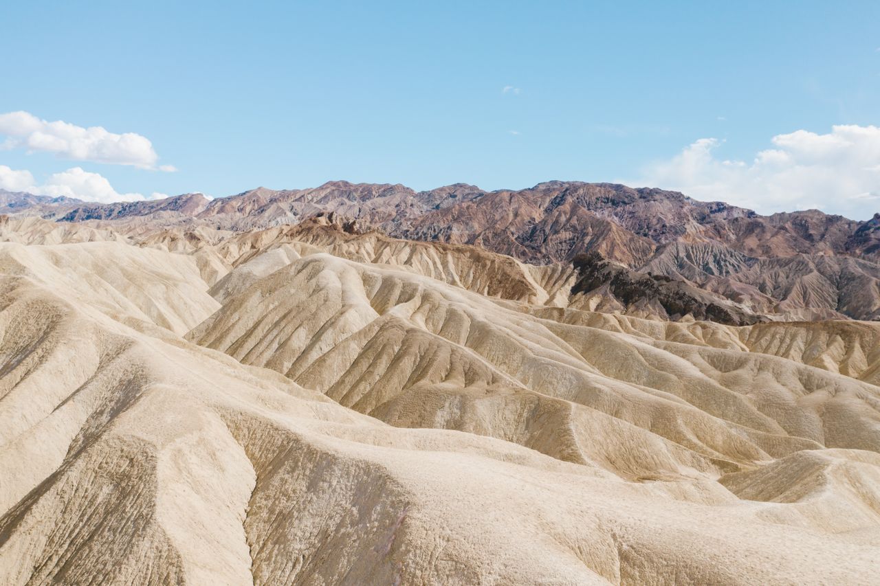
Death Valley earns its reputation as one of the most extreme landscapes in the country in ways that go well beyond the numbers — the lowest point in North America sits just miles from peaks over 11,000 feet, summer temperatures have hit a record 134°F, and some areas receive less than 2 inches of rain annually, making this the driest region in the United States. But the desert here is anything but flat and monotonous: colorful badlands, winding slot canyons, salt flats stretching to the horizon, and a genuine volcanic crater all sit within a short drive of each other.
This guide covers the best hikes in Death Valley, from easy canyon walks through demanding backcountry scrambles — with current 2026 road closure information, since several of the park’s most iconic attractions are genuinely inaccessible or restricted right now.
For gear appropriate to Death Valley’s extreme heat and sun exposure, our what to wear hiking in summer guide covers layering for genuinely dangerous heat conditions, and our best hiking sandals for women and best hiking boots for men guides cover footwear for loose gravel, sand, and slickrock terrain.
Before You Go — Essential 2026 Planning Information
Titus Canyon Road is closed for phase-2 repairs from October 1, 2026 through September 30, 2027. This is the iconic one-way scenic drive through the canyon and past the Leadfield ghost town covered later in this guide — it was only partially accessible earlier in 2026 following flood damage from 2022 that’s required years of repair work. Check nps.gov/deva directly for current status before planning any trip specifically around this drive.
Scotty’s Castle remains closed indefinitely, with no pedestrian access allowed since a 2015 flood caused extensive damage. There’s no announced reopening date.
Darwin Falls is closed, likely until at least summer 2027, after the access road washed out in places.
Lower Wildrose Road is closed through summer 2027 due to storm damage.
Given these closures, a first-time visit is safest and most rewarding sticking to the Furnace Creek-to-Stovepipe Wells corridor along Highway 190 and Badwater Road — every hike covered in the main sections of this guide sits along this accessible central corridor.
Entrance fees. $30 per vehicle, valid for 7 days.
Visit in spring, fall, or winter, not summer. Summer temperatures regularly reach well into the hundreds, and hiking during peak summer heat is a genuine safety risk rather than just discomfort.
Human footsteps can permanently damage delicate desert features, particularly the salt flat formations at Badwater Basin — tread carefully and stay on established paths where marked.
Easy Hikes
Golden Canyon — Best Introduction to Death Valley’s Geology
Distance: 2.9 miles round trip | Elevation gain: Minimal | Difficulty: Easy
Golden Canyon delivers a genuinely incredible variety of canyon landscapes in a single, mostly flat hike — golden-hued walls transitioning to red cliffs and rainbow-colored rock layers as you move deeper into the canyon. The hike starts with a dramatic entrance between towering canyon walls, and further in, the terrain takes on a maze-like quality with side canyons worth exploring in either direction.
A popular turnaround point is Red Cathedral, a striking red rock formation that rewards the walk in without requiring the additional elevation gain of continuing toward Zabriskie Point. This is a genuinely strong first hike for understanding the park’s dramatic geology without demanding serious physical effort.
Zabriskie Point via Golden Canyon and Gower Gulch Loop — Best Combined Loop Hike
Distance: Roughly 7.5 miles (loop) | Elevation gain: Moderate, with some scrambling | Difficulty: Moderate
For hikers who want to see considerably more than the standard Golden Canyon out-and-back, this loop connects Golden Canyon to the famous Zabriskie Point overlook and returns via Gower Gulch — a genuinely rewarding full circuit through some of the park’s best badlands scenery.
From the Golden Canyon trailhead, watch carefully for trail signage at the Badlands Junction — continuing straight leads to Gower Gulch, but this route continues uphill toward Zabriskie Point instead. The area has numerous unofficial “social trails” that can create confusion; always look for official trail markers and stay on the well-worn main path rather than following every visible track. The route climbs through Gower Gulch, where dark sediment washes downhill, before making a hard left up a connecting canyon toward the Zabriskie Point junction and the final uphill push through a narrow notch to the overlook itself.
Zabriskie Point delivers one of the finest viewpoints in the entire park, with interpretive displays and sweeping views back over the badlands you just hiked through — volcanic rock, sedimentary layers, distant salt flats, and on clear winter days, snow on the surrounding peaks. From here, you can also see back toward Manly Beacon and Red Cathedral, connecting the view directly to the trail you climbed.
The return route follows Gower Gulch back down toward Badwater Basin, passing visible evidence of the area’s mining history — old mine shafts, remnants of a road once paved specifically to service Borax mining operations, and genuinely spectacular geology throughout, including a stretch that feels almost lunar in its stark, otherworldly appearance. A short scrambling section through the gulch’s narrower points adds some genuine hands-on terrain before the trail opens back out near Badwater Basin and returns to the parking area.
Practical tip: You’re hiking directly across an active fault line on this route — the badlands side is sinking while the Panamint Range on the opposite side of the valley is rising, which is part of why Badwater Basin sits so dramatically below sea level.
Zabriskie Point (Standalone) — Best Quick Overlook Without a Full Hike
Distance: Roadside access, minimal walking required | Elevation gain: None | Difficulty: Easy
If you don’t have time for the full Golden Canyon loop, Zabriskie Point is directly accessible by a short paved path from its own dedicated parking area — genuinely one of the best viewpoints in the park for essentially no physical effort, delivering the same sweeping badlands panorama the full hike rewards you with after several miles of walking.
Zabriskie Point Overlook (Roadside) — Best Easy Badlands Photo Stop
Distance: Short paved walk from parking | Elevation gain: Minimal | Difficulty: Easy
A quick, easy walk up a paved path leads to a breathtaking view of striped, rolling badlands hills — shaped by layers of rock, volcanic ash, mud, and minerals creating a genuinely striking contrast of colors and textures. This is consistently cited as one of the most captivating and photogenic viewpoints in the entire park, and it requires almost no hiking to reach.
Artist’s Palette and Artist Drive — Best Colorful Rock Formation Hike
Distance: Variable, short trails from the main viewpoint parking | Elevation gain: Minimal | Difficulty: Easy
Artist’s Palette is the highlight along the scenic 9-mile Artist Drive winding through the Amargosa Mountains. You can admire the vibrant, multi-colored rock formations directly from the parking area, or hike deeper into the colorful hills for a genuinely maze-like experience with winding paths revealing new perspectives at every turn — including several small slot canyons worth ducking into.
Worth setting expectations honestly: the colors here are genuinely impressive in person but not always as intensely saturated as some heavily edited social media photos suggest — still well worth the stop, just don’t expect an exact match to the most dramatic images you may have seen online.
Badwater Basin — Best Otherworldly Salt Flat Walk
Distance: Short boardwalk path with unlimited additional walking onto the flats | Elevation gain: None (282 feet below sea level) | Difficulty: Easy
Badwater Basin sits at 282 feet below sea level, the lowest point in North America, and the salt flats here create genuinely fascinating geometric patterns in the dried salt deposits. A boardwalk path leads out from the parking area, and beyond that, you’re free to roam the flats at your own pace across this genuinely otherworldly landscape.
Practical tip: Tread carefully once you’re off the boardwalk — human footsteps can damage the delicate salt crystal patterns that make this spot so visually distinctive, and staying mindful of where you step helps preserve the formations for everyone who visits after you.
Mesquite Flat Sand Dunes — Best Dune Exploration
Distance: No formal trails; flexible distance depending on how far you explore | Elevation gain: Variable | Difficulty: Easy to Moderate
Named for the mesquite trees that grow in the area and provide genuine shelter and food for local wildlife, these dunes offer spectacular views against a mountainous backdrop with no formal trail system — you’re free to explore as much or as little as you like. A popular objective is climbing to the top of the tallest dune, though smaller dunes closer to the parking area offer a similar experience with far less walking.
Practical tip: Without marked trails, it’s genuinely easy to lose your bearings among the shifting sand formations — keep track of your direction back to the parking area, and avoid this hike entirely if strong wind is forecast.
Moderate Hikes
Mosaic Canyon — Best Slot Canyon Geology
Distance: 4 miles round trip | Elevation gain: Moderate | Difficulty: Moderate
Mosaic Canyon earns its name honestly — the swirling canyon walls genuinely resemble a mosaic art piece, with glossy fragments of rock held together by what looks like natural grout between them. The most breathtaking scenery is concentrated in the first quarter mile after the initial slot canyon section, where the trail opens into a wide wash surrounded by vividly colored mountains before narrowing again into a more mosaic-like slot further in.
Deeper into the canyon, the hike transitions into genuine canyoning territory rather than standard trail walking — if you’re short on time or don’t have canyoneering experience, this later section is entirely skippable without missing the canyon’s best scenery, which is concentrated much closer to the trailhead.
Sidewinder Canyon — Best Hidden Gem Slot Canyon
Distance: Variable depending on which side canyons you explore | Elevation gain: Minimal to moderate | Difficulty: Moderate
Sidewinder Canyon is a genuine hidden gem specifically because it doesn’t match the character of the park’s other, more famous canyons. From the parking lot, a wide wash leads through broad canyon walls, with several side canyons branching off worth exploring individually. One of these side canyons leads to a true slot canyon experience — narrow passages of gray and tan sedimentary rock swirling high overhead. Because this canyon sees meaningfully less traffic than Golden Canyon or Mosaic Canyon, it offers a genuinely quieter, more solitary hiking experience.
Ubehebe Crater — Best Volcanic Feature
Distance: Variable — rim walk, edge hike, or descent to the crater floor all possible | Elevation gain: Variable depending on route chosen | Difficulty: Easy (rim) to Moderate (descent)
Located at the far northern end of the park, Ubehebe Crater is genuinely unlike anything else in Death Valley — estimated at over 2,000 years old, formed when magma came into contact with groundwater and triggered a dramatic steam and gas explosion that carved out a crater roughly 600 feet deep. You can admire the formation from the rim, hike along the edge for varied perspectives, or descend to the crater floor for the more adventurous option.
Strenuous Hikes and Drives
Telescope Peak — Best Strenuous High-Elevation Hike
Distance: Roughly 14 miles round trip | Elevation gain: Substantial, reaching the park’s highest point | Difficulty: Strenuous
Telescope Peak stands in genuine contrast to everything else on this list — a big, high mountain hike that’s sometimes covered in snow, offering a completely different experience than the desert canyon and badlands hikes that dominate the rest of the park. Experienced Death Valley hikers who’ve covered the park extensively consistently name this their personal favorite hike specifically because of how different it feels from the valley floor terrain most visitors experience — a genuine alpine environment within the same park boundary as some of the hottest, driest desert in the country.
Dante’s View — Best Panoramic Overlook (Drive-Up)
Distance: Short paved walk from parking | Elevation gain: Minimal | Difficulty: Easy
While not a strenuous hike itself, Dante’s View earns a place among the park’s most dramatic destinations — a paved road winds up the Black Mountains to a lookout at roughly 5,500 feet, delivering what’s frequently described as the most grand view available anywhere in Death Valley. From here, the elevation contrast becomes genuinely comprehensible: you’re looking down at a valley floor sitting 282 feet below sea level, while peaks across the valley reach over 11,000 feet — one of the most dramatic elevation changes visible from a single viewpoint anywhere in the National Park System.
Titus Canyon Road — Currently Closed (Check Status Before Planning)
Distance: 27 miles, one-way (east to west) | Elevation gain: Substantial climbing over Red Pass, then descending | Difficulty: Moderate driving difficulty, requires high clearance in sections
This road is closed for phase-2 repairs from October 1, 2026 through September 30, 2027 — verify current status directly before planning around it. When open, this genuinely unique drive-through canyon experience is unlike anything else in the park: a 27-mile one-way route that can be completed in a two-wheel-drive vehicle, though one section requires higher clearance.
The first 6 miles follow a wash along a somewhat unremarkable dirt road before transitioning into vibrant desert mountain scenery as the route climbs Red Pass. The trail then descends to the ghost town of Leadfield, an early 1920s mining boomtown that lasted only a single year after gold deposits in the area turned out to be drastically exaggerated — essentially a mining scam, with only a few structures, cement foundations, and defunct mine shafts remaining today. From Leadfield, the drive continues down into the entrance of Titus Canyon proper, where towering canyon walls close in around the vehicle for a genuinely mesmerizing final stretch before emptying into Death Valley itself.
Building Your Death Valley Itinerary
One day: Golden Canyon in the morning, Badwater Basin and Artist’s Palette around midday, and Zabriskie Point or Dante’s View for sunset given how dramatically the badlands colors shift in low-angle light.
Two to three days: Day one covers the central Furnace Creek corridor — Golden Canyon, Zabriskie Point, Badwater Basin, and Artist’s Palette. Day two covers Mosaic Canyon and Mesquite Flat Sand Dunes near Stovepipe Wells, plus Ubehebe Crater if you have time for the drive north. Day three tackles Telescope Peak for a genuinely different, high-elevation experience, or Sidewinder Canyon for a quieter, less-trafficked slot canyon day.
Four or more days: Add the full Zabriskie Point-Golden Canyon-Gower Gulch loop as a dedicated half-day objective, and check whether Titus Canyon Road has reopened before building a day around that drive specifically.
Final Thoughts
Death Valley rewards visitors who understand its genuine extremes and plan around them rather than fighting them — visit in the cooler months, respect the very real heat danger of summer conditions, and check current road status carefully given how many of this park’s iconic attractions are genuinely affected by ongoing flood repair work in 2026. Start with Golden Canyon and Zabriskie Point to understand the park’s dramatic badlands geology, add Badwater Basin and Artist’s Palette for the otherworldly salt flats and colorful rock formations that define much of the park’s visual identity, and if you want a genuinely different experience within the same park, Telescope Peak’s high-elevation terrain is unlike anything else Death Valley offers.
Check nps.gov/deva directly for current status on Titus Canyon Road, Scotty’s Castle, Darwin Falls, and Lower Wildrose Road before finalizing any itinerary, and never underestimate how quickly extreme desert heat can turn dangerous — carry considerably more water than feels necessary on every hike in this guide.
For more national park hiking guides, check our best hikes in Zion National Park and best hikes in Bryce Canyon National Park guides for more of the desert Southwest’s finest hiking destinations.