
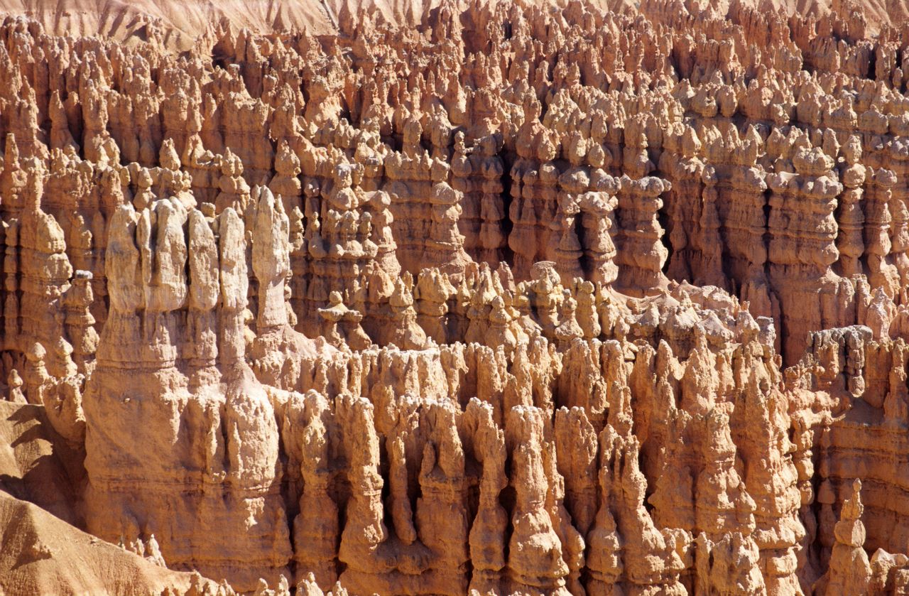
Bryce Canyon has one of the most immediately recognizable landscapes in the entire National Park System — thousands of red and orange hoodoos, the tall, thin spires of eroded rock that give the park its otherworldly character, packed into a natural amphitheater unlike anywhere else on Earth. But the park’s most famous views from the rim, spectacular as they are, only show you a fraction of what Bryce actually offers. Descending into the amphitheater itself — walking among the hoodoos rather than just looking down at them — is where this park genuinely comes alive, and it’s the difference most visitors miss if they only stop at the overlooks.
This guide covers the best hikes in Bryce Canyon, from paved, dog-friendly rim walks through the park’s most demanding backcountry-adjacent trails — with current 2026 fee, shuttle, and trail closure information, since Bryce’s most iconic trail section is under active construction this season.
For gear appropriate to Bryce’s steep switchbacks and high elevation, our best hiking poles guide covers options that reduce knee strain on the park’s descents and climbs, and our best hiking boots for men and best hiking boots for women guides cover footwear appropriate to the loose, sandy trail surfaces found throughout the amphitheater.
Before You Go — Essential 2026 Planning Information
Entrance fees. A standard 7-day vehicle pass costs $35, purchasable in advance as a digital pass on Recreation.gov or at the entrance station. A Bryce Canyon-specific annual pass runs $40, and the America the Beautiful Annual Pass at $80 covers entry to all national parks for 12 months. The park is entirely cashless — pay by card or a valid pass only.
International visitor surcharge. As of January 1, 2026, non-U.S. residents aged 16 and older pay an additional $100 surcharge on top of the standard entrance fee, part of the broader Interior Department policy now affecting Bryce Canyon, Zion, and several other high-traffic parks. This is waived for holders of the $250 America the Beautiful Non-Resident Annual Pass.
Wall Street is under active construction this season. Beginning June 15, 2026, the Wall Street side of the Navajo Loop closes Monday through Thursday from 6am to noon for critical trail stabilization work, continuing through the rest of the 2026 season. The Two Bridges side of Navajo Loop remains open throughout. If Wall Street specifically is a priority — and it’s widely regarded as one of the most beautiful stretches of trail in the entire park — plan your hike for a Friday, weekend, or afternoon outside the closure window, or check current status directly before you go, since Wall Street closes periodically even outside this specific construction schedule.
The park shuttle is free and voluntary, not mandatory. Riding it eliminates the genuine stress of navigating congested parking during peak season, and it’s included with any valid park entrance fee or annual pass — digital passes are required to board. The full shuttle loop takes about 50 minutes, and you can get on and off at any stop as many times as you like.
Elevation is a real factor throughout the park. Bryce sits between roughly 8,000 and 9,100 feet, running 10 to 20 degrees cooler than nearby Zion, and the amphitheater trails all involve a genuine climb back up regardless of how modest the net elevation gain looks on paper — descending into the amphitheater is the easy part, and the return climb at this altitude is where most visitors find the hike genuinely more demanding than expected.
Fire restrictions are currently in effect. As of late June 2026, Bryce Canyon is under Stage 2 Fire Restrictions — no campfires or charcoal fires of any kind, though petroleum and liquid propane stoves remain permitted. Check current fire status before any overnight or extended trip.
Water access is limited outside the main developed area. Water is available at the Visitor Center and Lodge, but there’s no water access along the Southern Scenic Drive — carry everything you’ll need for hikes accessed from that section of the park.
Easy Hikes — Accessible and Family-Friendly
Rim Trail — Best Easy Hike, and the Only Pet-Friendly Trail
Distance: Up to 10 miles total (flexible, walkable in shorter sections) | Elevation gain: Minimal | Difficulty: Easy
The Rim Trail does exactly what its name promises — tracing the edge of the Bryce Amphitheater with sweeping views down into the hoodoo formations below, without requiring the descent and return climb that every amphitheater trail demands. A substantial portion of the trail is paved, and that paved section is the only part of the entire park where pets are permitted, making this the clear choice for anyone hiking with a dog.
The full trail runs 10 miles, but it’s accessible from multiple points along the park road, meaning you can walk as short or long a section as you want rather than committing to the full distance. This is also the trail most commonly recommended for visitors who can’t manage the amphitheater’s steeper descents and climbs — the views are genuinely excellent even without descending into the canyon itself.
Bristlecone Loop — Best Easy Trail at Rainbow Point
Distance: 1 mile (loop) | Elevation gain: Minimal | Difficulty: Easy
Located at Rainbow Point, the very end of the park’s Southern Scenic Drive, this easy loop passes through a genuine bristlecone pine forest — some of the oldest living trees on Earth — with a couple of overlooks along the way delivering wide-open views of the surrounding landscape. There’s essentially no elevation gain, though the path itself is uneven with roots and rock, worth knowing for anyone expecting a fully smooth, effortless walk.
This trail gets genuinely busy during peak hours in warmer months, and it’s inaccessible in winter once snow covers the trail. Rainbow Point itself, at the southern terminus of the scenic drive, is not accessible during winter months at all, since the road isn’t maintained that far south once snow arrives.
Mossy Cave — Best Short Hike With Multiple Landmarks
Distance: Roughly 0.9 to 1 mile round trip | Elevation gain: 120 feet | Difficulty: Easy
Mossy Cave sits outside the main park boundary entirely — reached by driving east on Highway 12 from Bryce Canyon City, about a 15-minute drive from the main park area — which keeps this genuinely beautiful short trail considerably less crowded than the amphitheater trails despite its easy accessibility and worthwhile scenery.
The trail forks partway through: one direction leads to Mossy Cave itself, a small alcove with moss growing on the overhung rock, sometimes still showing ice formations in spring from water that froze over winter. The other direction leads to a small waterfall and a set of rock formations called the Windows — widely reported by hikers as the more memorable half of this short hike, with crystal-clear water flowing through vivid orange rock. This waterfall is the only non-seasonal waterfall in the entire park, meaning it runs year-round rather than depending on snowmelt or seasonal rain. The trail even includes a few hoodoos of its own, a nice bonus for a hike this short and this easy.
Inspiration Point — Best Multi-Level Overlook With Minimal Hiking
Distance: Under 1 mile total for all three levels | Elevation gain: Minimal | Difficulty: Easy
Inspiration Point is worth including specifically because it delivers three distinct overlook levels, each at a slightly different elevation into the Bryce Amphitheater, all reachable with less than a mile of total walking from the parking area. This makes it a genuinely efficient stop for visitors with limited time or mobility who still want the classic Bryce panoramic view.
Located within the first few miles of the park road, Inspiration Point remains accessible even during winter snow closures that shut down more remote sections of the park, making it a reliable option for cold-season visits when many of the park’s longer trails aren’t viable.
Moderate Hikes
Queen’s Garden and Navajo Loop (Combined) — Best Single Trail for First-Time Visitors
Distance: Roughly 3 to 3.1 miles (combined loop) | Elevation gain: Roughly 600 to 650 feet | Difficulty: Moderate
If you can only do one trail in Bryce Canyon, this combined loop is consistently the answer experienced visitors and repeat hikers give. Starting at Sunset Point, the trail descends the Navajo Loop’s switchbacks — passing directly beneath Thor’s Hammer, the single most iconic and recognizable hoodoo in the park — before winding through the Queen’s Garden section, where two natural rock bridges and dramatic archways frame the path. The trail then climbs back to the rim, often via a return along the Rim Trail from Sunrise Point back to your starting point at Sunset Point.
Don’t underestimate the climb back regardless of the modest 600-plus foot elevation figure — at roughly 7,500 to 8,000 feet of elevation, the ascent genuinely challenges hikers who aren’t acclimatized, a detail multiple visitors specifically flag as more demanding than the numbers alone suggest. Hiking this loop at sunrise specifically is widely recommended: the early light on the hoodoos is spectacular, and crowds are meaningfully smaller than later in the day on what is consistently one of the most popular trails in the entire park.
A note on naming within Queen’s Garden: two rock formations along the trail are informally named Queen Victoria and Queen Cassandra — a fun bit of pattern-recognition scavenger hunting that most hikers enjoy trying to spot, with varying success, as the visual resemblance is left to interpretation.
Peekaboo Loop — Best Overall Hiking Experience in the Park
Distance: Roughly 5 to 5.2 miles | Elevation gain: Roughly 1,450 to 1,600 feet | Difficulty: Moderate to Strenuous
Peekaboo Loop is frequently cited by experienced Bryce hikers as the single best trail in the entire park, and the reasoning holds up — it winds directly through the amphitheater past a genuinely dense concentration of unique rock formations, including a section called the Windows (massive arches sitting atop the amphitheater, distinct from the Windows found near Mossy Cave) and a collection of hoodoos known as the Hindu Temples. Crowds here run noticeably lighter than on the more famous Navajo Loop, which is itself a real point in this trail’s favor.
Access is available from either Bryce Point or by connecting directly from the Navajo Loop trail system, and many experienced hikers combine Peekaboo Loop with Navajo Loop and Queen’s Garden into one longer, more comprehensive day — a route that covers essentially the best of what Bryce’s amphitheater trails offer in a single, extended outing.
Hat Shop — Best Trail for Genuine Solitude
Distance: Roughly 4 miles round trip | Elevation gain: 1,000 feet | Difficulty: Moderate
Accessed from Bryce Point, the Hat Shop is the first leg of Bryce’s Under the Rim Trail — a longer backcountry route most visitors have never heard of, and hiking even just this first section leads away from the Bryce Amphitheater entirely, which is exactly why it stays so quiet. This isn’t a trail for wide-open panoramic views; the payoff is a specific destination — a cluster of unusual hoodoos capped with wider “hat-shaped” tops, distinctive enough to be genuinely worth the walk.
Multiple hikers report seeing only one or two other people on this entire trail even during peak season, a genuinely rare experience in a park that saw nearly 2 million visits in 2025. If crowds elsewhere in the park are wearing on you, this is the trail built specifically to solve that problem.
Swamp Canyon — Best Trail for Escaping Crowds Entirely
Distance: 4.5 miles (using the Sheep Creek Trail to loop back) | Elevation gain: 850 feet | Difficulty: Moderate
Swamp Canyon is the trail most likely to fly entirely under the radar, and for understandable reasons — it doesn’t offer the hoodoo-dense scenery that defines Bryce’s famous amphitheater trails. What it does offer is genuine, reliable solitude in a park that’s otherwise consistently crowded; hikers report seeing as few as two other people across the entire trail. Starting at the Swamp Canyon Overlook on the Southern Scenic Drive, the route delivers a few worthwhile views toward Swamp Canyon Butte in the distance, but the real draw here is simply finding quiet space in a park that rarely offers it.
Strenuous Hikes
Fairyland Loop — Best Underrated Strenuous Trail
Distance: 8 miles | Elevation gain: 1,600 feet | Difficulty: Strenuous
Located just outside the park’s main entrance, Fairyland Loop is widely regarded by experienced Bryce hikers as the single most underrated trail in the entire park — its length and elevation gain scare off a meaningful share of visitors, which means the trail stays considerably less crowded than the shorter amphitheater loops despite genuinely comparable scenic quality. Notable landmarks along the route include the China Wall, a long, narrow rock fin, and Tower Bridge, a distinctive natural rock arch formation.
Hiking this trail near golden hour is particularly rewarding — the landscape genuinely appears to glow in the low-angle light, an effect that’s especially striking when passing a formation nicknamed the Castle of the Fairy Princess. One important seasonal note: the access road to the Fairyland trailhead isn’t plowed in winter, meaning this trail is effectively inaccessible during the colder months regardless of how much you might want to hike it.
Overlooks Worth Visiting Without a Full Hike
Rainbow Point, at the very southern end of the park along the Scenic Drive, requires no hiking at all — simply drive to the end of the road for sweeping views, though this stop combines naturally with the nearby Bristlecone Loop and Rainbow Point overlook trails if you want to add a short walk. This section of the park closes during winter months since the road isn’t maintained that far south once snow arrives.
Thor’s Hammer, the park’s most iconic individual hoodoo, is visible directly from Sunset Point without any hiking required at all — or, for a closer view many hikers consider the better vantage point, descend just the first few switchbacks of the Navajo Loop to see it from just below rather than from above.
Building Your Bryce Canyon Itinerary
One day: Queen’s Garden and Navajo Loop combined at sunrise, followed by Inspiration Point and a walk along a section of the Rim Trail, finishing with Mossy Cave in the late afternoon if you have time to leave the main park area.
Two to three days: Day one covers the combined Queen’s Garden and Navajo Loop at sunrise, plus the Rim Trail sections near Sunset and Sunrise Points. Day two covers Peekaboo Loop, ideally combined into an extended route with Navajo Loop and Queen’s Garden for hikers who want the park’s full amphitheater experience in one longer day. Day three covers Fairyland Loop for a genuinely strenuous, less crowded full day, or the Hat Shop and Swamp Canyon for hikers who specifically want solitude over scenery.
Four or more days: Add Bristlecone Loop and Rainbow Point as a lower-effort day at the far southern end of the park, and consider Mossy Cave as a relaxed half-day outing outside the main park boundary — a nice change of pace from the amphitheater’s steeper trails.
Final Thoughts
Bryce Canyon rewards hikers who actually descend into the amphitheater rather than stopping at the rim — the difference between viewing the hoodoos from above and walking among them at ground level is genuinely significant, and it’s the single biggest reason repeat visitors keep coming back. Start with the combined Queen’s Garden and Navajo Loop to understand why this trail earns its reputation as the park’s essential first hike, add Peekaboo Loop once you’re ready for more distance and fewer crowds, and if solitude matters more to you than hoodoo density, the Hat Shop and Swamp Canyon deliver genuinely quiet trail time in one of the most consistently crowded parks in the National Park System.
Check the current Wall Street closure schedule before planning around that specific section, respect the real elevation demands of every amphitheater trail’s return climb, and hike at sunrise whenever possible — the light, the temperature, and the crowds are all working in your favor at that hour.
For more national park hiking guides, check our best hikes in Zion National Park and best hikes in Grand Canyon National Park guides.