
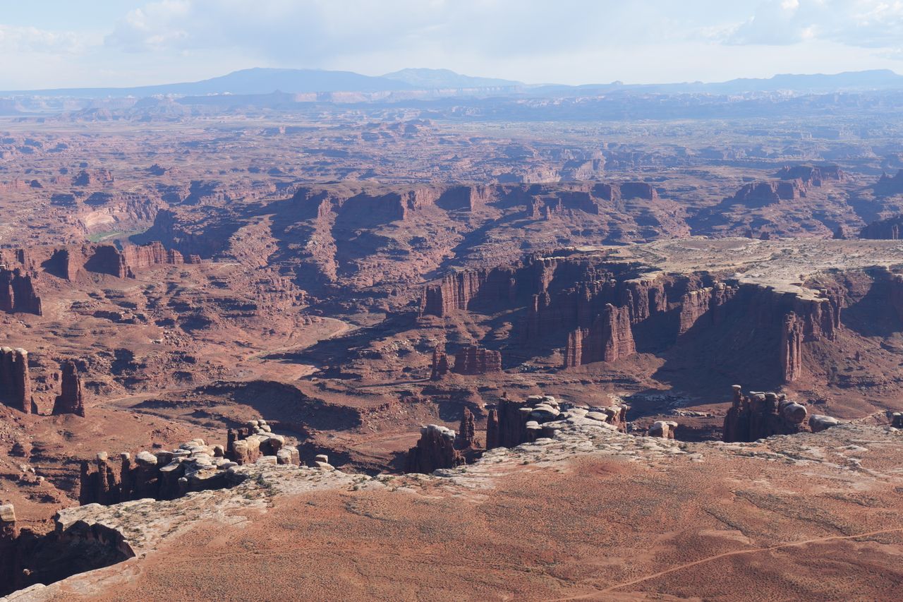
Canyonlands is Utah’s largest national park at 337,598 acres, and it’s genuinely structured differently than almost any other park in the system — the Green and Colorado Rivers split it into three major districts (Island in the Sky, the Needles, and the Maze), and there’s no road anywhere that crosses the rivers to directly connect them. Traveling between districts, even ones that look close together on a map, takes two to six hours by car, which is exactly why most visitors realistically choose to focus on just one or two districts per trip rather than trying to cover the whole park at once.
This guide covers the best hikes across Canyonlands’ most accessible districts — Island in the Sky, the Needles, and the remote Horseshoe Canyon unit — with current 2026 access information, including an active closure that genuinely affects part of this guide right now.
For gear appropriate to Canyonlands’ exposed, remote desert terrain, our what to wear hiking in summer guide covers sun protection layering, and our best hiking boots for men and best hiking boots for women guides cover footwear for slickrock and sandy terrain.
Before You Go — Essential 2026 Planning Information
Active fire closure in the Needles District. As of late June 2026, Canyonlands has temporarily closed the entire Needles District to all uses, including backcountry access, due to the Babylon Fire burning near Blanding, Utah. This directly affects Druid Arch, Chesler Park, and Cave Spring Trail, all covered later in this guide — check the current status on nps.gov/cany before planning any Needles District trip, since this closure could still be in effect or could have changed by the time you’re reading this.
No timed entry reservation is required anywhere in Canyonlands. Unlike neighboring Arches, this park has never implemented a timed-entry system — you simply pay the standard entrance fee and enter.
Entrance fees. $25 per private vehicle, $10 per individual on foot or bicycle, valid for 7 days. This same pass covers Arches, Hovenweep, and Natural Bridges as well. A $55 annual Southeast Utah pass covers all four of those sites for a full year.
Backcountry permits are required for all overnight hiking or off-roading, and reservations, while not strictly mandatory, are strongly recommended through Recreation.gov starting four months before each season — particularly for the Needles District or the White Rim Road during the popular spring and fall shoulder seasons.
There are no roads directly connecting the park’s districts, and no food, gas, or supplies available inside the park at all. The Needles Outpost, a private campground just outside the Needles District, sells basic gas and food spring through fall — otherwise, arrive fully stocked.
May is typically the busiest month, and spring and fall are the best overall times to visit given summer heat. There is little to no shade or reliable water on nearly every trail in this guide — carry considerably more water than feels necessary, especially for anything in the Needles or Horseshoe Canyon.
Island in the Sky District — The Most Accessible Section
Mesa Arch — Best (and Most Popular) Short Hike in the Park
Distance: 0.7 miles round trip | Elevation gain: 88 feet | Difficulty: Easy
Mesa Arch is almost certainly the single most photographed spot in all of Canyonlands, and it’s likely what a large share of visitors come to this park specifically to see. At sunrise, the sun rises directly through the arch’s opening with the La Sal Mountains framed in the background and the canyon dropping away below — a genuinely spectacular, bucket-list composition that draws serious crowds.
If you’re hiking this at sunrise specifically, be ready to share the small viewing area with what can feel like thousands of photographers jockeying for position — the experience is genuinely more crowded than the trail’s short, easy distance might suggest. Budget extra time for parking too, since the lot fills well before sunrise during peak season.
Grand View Point — Best Easy Escape From the Crowds
Distance: Sweeping views within feet of the parking lot; 1.8 miles round trip with 160 feet of elevation gain for the full mesa-tip hike | Difficulty: Easy
Grand View Point marks the farthest south you can drive within the Island in the Sky district, and the views here are genuinely spectacular in every direction within just a few feet of the parking area — which is exactly why an estimated 99% of visitors never walk any further than that immediate viewpoint. For hikers willing to continue to the actual tip of the mesa overlooking the canyon below, the trail delivers real solitude specifically because so few visitors bother to walk it.
Upheaval Dome — Best Unique Geology Hike
Distance: 1.3 miles round trip (shorter option to the first overlook available) | Elevation gain: 226 feet | Difficulty: Moderate
Upheaval Dome sits at the far western tip of the Island in the Sky district, and it delivers a genuinely different visual experience than anywhere else covered in this guide — rather than sweeping canyon views or classic arch photography, this trail leads to a bizarre, dramatically uplifted geological structure that most geologists now believe formed roughly 60 million years ago when a meteorite roughly a third of a mile in diameter struck this exact spot, though some researchers have also proposed an alternative salt dome origin. Scientists still aren’t fully certain which theory is correct, which adds a genuine layer of mystery to what’s already one of the most visually unusual formations in the park.
For hikers with less time or energy, walking just to the first overlook delivers a solid taste of the formation without committing to the full route.
Whale Rock — Best Scramble for Families
Distance: 0.8 miles round trip | Elevation gain: 131 feet | Difficulty: Easy to Moderate (with genuine scrambling)
Whale Rock is visible from the parking lot or even just driving past on the way to the Upheaval Dome trailhead, but it’s genuinely worth the short hike out rather than settling for the distant view. Unlike most of the overlook-style stops in this district, Whale Rock lets you actually scramble and climb around on smooth sandstone — a genuinely fun, hands-on stop that kids in particular tend to love.
White Rim Overlook Trail — Best Flat Hike With a Colorado River View
Distance: Roughly 2 miles round trip | Elevation gain: Minimal | Difficulty: Easy
This trail is frequently cited as a personal favorite overlook in the entire Island in the Sky district — a notably flat walk across the plateau leading to what many repeat visitors consider the single best view of the Colorado River canyon available anywhere in this district. Every overlook in Island in the Sky delivers genuinely strong views, so this specific hike isn’t necessarily worth going out of your way for purely on that basis, but as a nice, easy plateau walk with a rewarding payoff at the end, it’s a genuinely solid choice.
Roadside Stops in Island in the Sky
Shafer Canyon Overlook and Shafer Trail Viewpoint sit within a half mile of each other, each requiring only a few hundred feet of walking, and both deliver different, equally impressive vantage points of the dramatic Shafer Trail Road switchbacking below.
Candlestick Tower Overlook requires roughly a tenth of a mile of walking to the viewpoint’s edge, delivering a fast, easy view of a striking standalone rock formation and the western side of the park overlooking the Maze district in the distance.
Dead Horse Point State Park, technically outside Canyonlands but just a 20-minute drive from the Island in the Sky Visitor Center, is genuinely worth the detour — note that the national park pass doesn’t cover entry here, but a Utah state parks pass does. There’s minimal formal hiking, but the viewpoint at the end of the road delivers beautiful views over the Island in the Sky district, the Potash ponds, and the La Sal Mountains, best at sunrise specifically.
The Needles District — Currently Closed (Check Status Before Planning)
Important: as of this writing, the entire Needles District is closed to all uses, including backcountry access, due to the Babylon Fire. The trails below represent what’s normally available in this district and should only be planned once the closure is confirmed lifted.
Chesler Park — Best Full-Day Hike in the Needles
Distance: 11 miles (loop) | Elevation gain: Substantial | Difficulty: Strenuous
Chesler Park is widely considered the heart and soul of Canyonlands — the area’s beauty is genuinely what originally inspired the push to protect this section as parkland in the first place. The loop hikes along the top of buttes with needle-like rock formations visible below, passes through slot canyons narrow enough to require genuine shimmying through in sections, and opens unexpectedly into flat plains where desert wildflowers bloom in a way that feels genuinely unusual for this kind of arid terrain — particularly striking in May.
Hike this counterclockwise rather than clockwise. Going counterclockwise puts the steepest section on the descent; going clockwise (a mistake more than one hiker has made) means climbing the steepest section right near the end of an already long, tiring day. At 11 miles with real heat exposure even in relatively cooler months, water consumption on this hike is genuinely significant — some hikers report going through 4 liters of water on a single May hike, more than they expected despite starting before sunrise specifically to beat the heat.
Druid Arch — Best Underrated Hike in the Needles
Distance: 10.4 miles round trip | Elevation gain: 1,614 feet | Difficulty: Strenuous
Druid Arch is genuinely underrated relative to how good it actually is, and the reason is almost entirely about access — the drive from Moab to this specific trailhead runs roughly an hour and a half one-way, since Druid Arch sits in the Needles District, considerably closer to Monticello than to Moab itself. That distance alone keeps many repeat Moab visitors from ever discovering this trail, sometimes for years.
Combined with the long drive, the hike itself demands real commitment as a full day trip, or an overnight stay closer to the trailhead. The arch itself, once you reach it, is genuinely unique and considered well worth the extended effort by hikers who make the trip.
Cave Spring Trail — Best Short Hike With Real History
Distance: 0.6 miles (loop) | Elevation gain: Minimal, with a short ladder climb | Difficulty: Easy
Cave Spring is a genuinely rewarding short trail specifically because of what it preserves rather than pure scenery — a preserved cowboy camp from when this entire area operated as a 1.8-million-acre cattle ranching operation, with Texas-based outfits among the companies that once ran cattle through this exact terrain. The park has left much of the original camp setup intact, with some elements recreated, and a genuine spring dripping through the rocks (with some vegetation growth around it) provides the water source the camp’s name references.
A short series of ladders lets you climb up onto the rock above — a fun, minor scramble that rewards you with sweeping views across the surrounding Needles District landscape. This is a genuinely strong “best bang for your effort” short hike in this district.
Horseshoe Canyon — The Remote Detached Unit
Horseshoe Canyon (Great Gallery) — Best Hike for Ancient Rock Art
Distance: Roughly 7 miles round trip | Elevation gain: Concentrated in the first mile (canyon descent), flat thereafter | Difficulty: Strenuous (due to remoteness and distance, not technical terrain)
Horseshoe Canyon is protected as its own detached section of the park specifically because of its exceptional concentration of ancient rock art. Reaching the trailhead requires driving roughly an hour and a half from Green River, Utah, including a stretch of genuinely remote dirt road — this is not a casual add-on to an Island in the Sky day, but a dedicated trip in its own right.
The hike itself descends the canyon wall for the first mile before leveling out into a flat, genuinely gorgeous canyon floor — hiked in May, the canyon can be filled with wildflowers and blooming trees, adding real beauty beyond just the archaeological interest. Throughout the hike, you’ll pass numerous petroglyph and pictograph panels, including the famous Holy Ghost panel, estimated at more than 2,000 years old — long, narrow, genuinely haunting figures that represent some of the most significant rock art in the American Southwest. Many experienced repeat visitors to this broader region name this among their single favorite hikes anywhere.
Scenic Drives Worth Knowing About
The Needles scenic drive is frequently cited as the second-best scenic drive in the park after the Shafer Trail, passing the genuinely striking Newspaper Rock petroglyph panel — a roadside stop with an extraordinary concentration of rock art directly visible from the road, worth stopping for even if you don’t hike another step that day.
The Shafer Trail is an unpaved 19.6-mile route connecting Moab to Canyonlands, passing the Potash ponds and the lower section of Dead Horse Point State Park along the way. This requires four-wheel or all-wheel drive with real ground clearance — it’s a driving experience rather than a hike, but it’s regularly cited as one of the most scenic routes in the entire region, and much of it sits outside both the national park and any wilderness area, meaning drone photography is permitted along significant stretches.
Building Your Canyonlands Itinerary
One day: Mesa Arch at sunrise, followed by Grand View Point, Upheaval Dome, and Whale Rock through the rest of the morning and early afternoon — a genuinely complete Island in the Sky sampler in a single day.
Two to three days: Day one covers Island in the Sky’s main hikes (Mesa Arch, Grand View Point, Upheaval Dome, Whale Rock, White Rim Overlook) plus Dead Horse Point State Park at sunset. Day two, if the Needles District is open, covers Cave Spring Trail and either Chesler Park or Druid Arch as a full-day objective. Day three covers Horseshoe Canyon as a dedicated remote excursion, or the Shafer Trail as a scenic driving day if you have the right vehicle.
Four or more days: Add both Chesler Park and Druid Arch as separate full-day Needles objectives if the district is open, and build genuine buffer time around the long drives between districts — this park punishes overly ambitious multi-district itineraries more than almost any other in the system.
Final Thoughts
Canyonlands rewards visitors who accept its genuinely fragmented geography rather than fighting it — pick one or two districts per trip, and plan around the reality that reaching a different section of the same park can take longer than driving to an entirely separate national park elsewhere in Utah. Start with Island in the Sky’s easy, high-payoff cluster of hikes for a first visit, add Chesler Park or Druid Arch in the Needles once you’re ready for a genuine full-day commitment (checking current fire closure status first), and if ancient rock art interests you, Horseshoe Canyon delivers some of the most significant petroglyph and pictograph panels in the entire American Southwest.
Check the current Needles District closure status before planning any trip to that section, carry serious water reserves on every hike in this guide, and build real time buffers into any multi-district itinerary given how genuinely far apart these sections of the park actually are.
For more national park hiking guides, check our best hikes in Arches National Park and best hikes in Bryce Canyon National Park guides for more of southern Utah’s finest hiking destinations.