
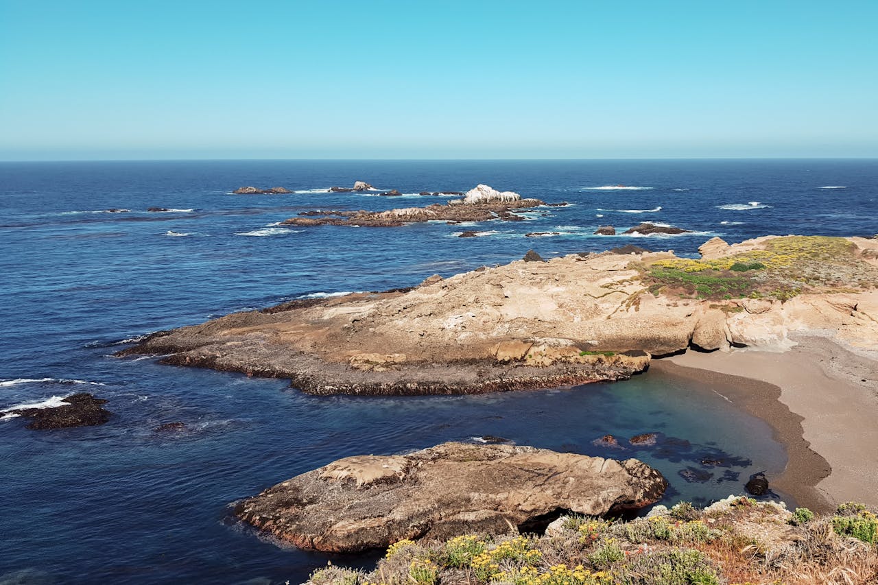
Point Lobos State Natural Reserve sits at the northern end of Big Sur, 15 minutes south of Monterey, and manages to pack more coastal beauty into 400 acres than most California parks deliver across ten times that space. Monterey cypress groves found nowhere else on earth. Sea lion coves visible from the trail. A dramatic stone arch rising from the ocean. Protected marine areas visible through water so clear you can see kelp forests from the coastal bluffs. And trail after trail that stays under a mile while delivering views that stop you in your tracks repeatedly.
It’s one of those places that earns the word extraordinary without hyperbole — and it’s one that most visitors to the Monterey Peninsula underestimate until they’re standing on the first coastal overlook and realize they’ve found something genuinely special.
This guide covers every trail worth hiking at Point Lobos, the logistics that make or break a visit, and everything you need to get the most out of one of California’s finest state natural reserves.
Before You Go: Essential Planning Information
Entry fee: Point Lobos charges a day-use parking fee — currently $10 per vehicle. The America the Beautiful Annual Pass covers this fee. Pay at the entrance station on arrival.
Parking is the biggest variable in your visit. The park has a limited number of parking spaces distributed across several small lots, and it fills consistently on weekends, holidays, and summer mornings. When the lots fill, entry closes and visitors must wait for spaces to open as others leave — or park on Highway 1 outside the reserve boundary and walk in, which adds significant distance to reach the trails.
The practical solution: arrive when the park opens or as close to it as possible. Early morning visits also benefit from the best light through the cypress trees and the quietest trail conditions before day hikers arrive. If you’re staying in Monterey, the 15-minute drive makes a 7am arrival genuinely feasible.
Getting there: The reserve is located on Highway 1 approximately 3 miles south of Carmel-by-the-Sea. From Monterey, drive south on Highway 1 for about 15 minutes. GPS navigation works reliably to the park entrance.
Where to stay: Monterey and Carmel are the two closest accommodation bases — both within 15-20 minutes. Carmel puts you slightly closer and has a more intimate scale for visitors focused on the Big Sur coast. For hikers who want to combine Point Lobos with Big Sur itself, staying further south in Big Sur Village or at one of the campgrounds along Highway 1 provides access to both areas.
What to bring: Even on sunny days, the coastal wind at Point Lobos is significant — a light wind layer or packable rain jacket is worth having for extended time on the exposed bluff overlooks. Water is important despite the short trail distances — the views genuinely invite longer stops than the mileage suggests, and cumulative time on trail exceeds what the distances indicate. Our best hiking backpacks with a water bladder guide covers compact hydration options appropriate for half-day coastal hiking.
Wildlife expectations: Sea lions and harbor seals are present at multiple coves throughout the reserve. Sightings are common but not guaranteed on any single visit — populations and behavior vary by season. Spring and early summer bring larger numbers of harbor seals to the coves. Marine mammals are protected — maintain a respectful viewing distance and never approach animals in or near the water. Bird life throughout the reserve is excellent year-round, with the Bird Rock trail providing the best dedicated birding experience.
The Trails — What to Hike and in What Order
Point Lobos is compact enough to do multiple trails in a single half-day visit — which is the recommended approach. The park’s parking is divided across several small lots serving different trail clusters. Planning your trail sequence around the lot locations minimizes backtracking and maximizes what you see in the time available.
Cypress Grove Trail — Best Trail in the Park
~1 mile round trip | Allen Memorial Grove parking lot | Easy
The Cypress Grove Trail is the single best trail in Point Lobos and arguably one of the finest one-mile trails anywhere on the California coast. The combination it delivers — an ancient grove of Monterey cypress trees, multiple coastal overlooks with views toward Monterey Bay, and the distinctive red-orange algae that colors the cypress bark — creates a trail experience that feels genuinely singular rather than generically beautiful.
The Monterey cypress is one of the rarest trees on earth. It grows naturally in only two locations in the world — both near Carmel, and Point Lobos is one of them. The Allen Memorial Grove, named for the family that sold and later donated this land to the park beginning in the 1930s, preserves the largest naturally occurring stand. The trees grow in shapes sculpted by decades of coastal wind — dramatically twisted, asymmetrical, extending horizontally in ways that vertical forest trees never do.
The trail is a loop that leaves the cypress grove briefly to reach a series of coastal overlooks on the point itself before returning through the trees. The overlooks are the emotional peak of the trail — sitting on a rock above the Pacific with the cypress trees framing the view on either side and the offshore rocks visible through the coastal haze is an experience worth far more than the mile of walking required to reach it.
Budget significantly more time than the one-mile distance suggests. Most hikers spend 45 minutes to an hour on this trail despite its length — the overlooks genuinely invite sitting rather than passing through, and the grove itself warrants unhurried attention. Morning light filtering through the cypress creates photograph opportunities that the flat midday light doesn’t replicate.
The red-orange color on the bark of many trees comes from a specific algae species growing on the cypress — a detail worth noticing because it appears directionally rather than wrapping around the branches, oriented toward the prevailing light and moisture source. It’s a specific natural phenomenon that adds biological interest to what is already a visually distinctive grove.
Practical tip: This trail shares a parking lot with the Sea Lion Point Trail — do both consecutively from the same parking area rather than moving the car between them.
Sea Lion Point Trail — Best Easy Wildlife Walk
Less than 0.5 miles round trip | Allen Memorial Grove parking lot | Easy | Wheelchair Accessible
The Sea Lion Point Trail leaves from the same parking area as the Cypress Grove Trail and reaches an overlook above a cove where sea lions and harbor seals gather on the rocks below. The trail is wheelchair accessible, takes less than 30 minutes, and adds a wildlife dimension to the Cypress Grove parking area that makes the combination of both trails the obvious first move for any Point Lobos visit.
Multiple benches along the Sea Lion Point Trail provide comfortable positions for extended wildlife watching — sea lions are most active in the morning hours and the overlook position above the cove allows observation without disturbing the animals. Previous visitors to the cove have reported significant numbers of both California sea lions and harbor seals on the rocks; populations vary by season and day, so manage expectations while being prepared for a rewarding sighting.
The trail loops back to the parking area after the main overlook, but hikers doing the full park loop can continue directly from Sea Lion Point toward the Bird Island Trail rather than returning to the lot — a route that chains the experiences of the western park section into a single continuous walk.
Practical tip: Binoculars significantly enhance the sea lion experience from the overlook — the cove distance makes close observation difficult with the naked eye. A compact pair weighing a few ounces is worth including in your day pack for any Point Lobos visit.
Bird Island Trail — Best Trail for Views and Wildlife Combined
Less than 1 mile round trip | Bird Island parking lot | Easy | Partially Wheelchair Accessible
The Bird Island Trail is the favorite among repeat Point Lobos visitors — a short walk that delivers more visual variety per step than any other trail in the reserve. The trail begins at a separate parking lot from the Cypress Grove area, requiring a short drive or a longer walk if you’re connecting from the western trails.
The opening section runs along an elevated path above China Cove — the reserve’s most photogenic cove, a small turquoise bay enclosed by the coastal geology that concentrates the deep blue-green water in a way that reads as almost impossibly vibrant on clear mornings. Multiple benches along this section provide positions for viewing harbor seals on the cove rocks below — on most visits to this trail, seals are visible without any waiting.
China Cove itself is accessible via a path descending from the main trail to a small beach — worth exploring for hikers who want to spend time at the water rather than just viewing from above. The beach is protected enough from coastal swells to be genuinely accessible rather than just theoretically reachable.
The trail continues around the back of a small hill to reach Bird Rock — a significant offshore rock formation where large numbers of cormorants, pelicans, and other seabirds congregate during peak season. The population varies dramatically by time of year; spring and early summer bring the largest numbers. The rock also contains a natural stone arch approximately 25-30 feet tall that rises from the water at the base of the rock — one of the finest natural arches on the California coast and one that’s easily missed by visitors who don’t know to look for it.
The arch is the trail’s hidden highlight — visible from the main viewpoint at Bird Rock if you know to look below the bird colony for the opening in the rock. It’s a photography target worth finding.
The trail is an out-and-back, returning the same way to the parking lot after reaching Bird Rock.
Practical tip: The Bird Island parking lot is even smaller than the Cypress Grove lot — genuinely limited to a handful of vehicles. Arriving early or combining this trail as part of the longer park loop avoids the parking situation entirely.
Whalers Cove and Whaling Museum Loop — Best Historical Addition
Less than 0.5 miles | Whalers Cove parking area | Easy
Whalers Cove sits near the park entrance and provides both historical content and additional coastal viewpoints that most visitors skip in favor of the more famous trails. The historic whaling cabin on this section of the trail dates to the 1850s — one of a dozen shore-based whaling station cabins that once operated along this stretch of coast, now preserved as a museum with interpretive exhibits on the abalone and whale oil industries that made this cove commercially significant in the mid-19th century.
The whaling industry at this location operated until kerosene oil made whale oil economically obsolete — a transition that inadvertently saved the whale populations of the California coast and allowed the marine ecosystem that now makes Point Lobos one of the finest scuba diving locations on the California coast. The museum docents are knowledgeable about local history and worth engaging if the cabin is staffed during your visit.
The trail from the Whalers Cove parking area provides views over the cove itself and out toward Monterey Bay before reaching the museum — making it a combined historical and coastal experience that adds context to the reserve’s human history alongside its natural features. Whalers Cove is considered one of the best shore-entry scuba diving sites in California, and divers entering and exiting the water are a common sight at this section of the park.
Practical tip: The Whalers Cove area is worth visiting on the way into or out of the park rather than as a dedicated driving stop — its proximity to the park entrance makes it the most conveniently added component of any Point Lobos itinerary.
The Complete Reserve Loop — Best Full-Day Experience
~6 miles | Full park | Moderate
For hikers who want to see the full reserve rather than the individual trail highlights, the complete perimeter loop covers approximately 6 miles and follows the coastal edge of the entire 400-acre reserve. This route passes through all the major trail sections — the Cypress Grove, the Sea Lion Point area, the Bird Island section, and the coves and headlands between them — providing a complete picture of the reserve’s geography.
The loop takes significantly longer than the mileage suggests — budget 4-5 hours minimum for hikers who plan to stop at overlooks, watch wildlife, and give the cypress grove the time it warrants. Many hikers starting with the full loop intention end up spending far longer than planned because the individual sections are compelling enough to stop at for extended periods.
The full loop is the right choice for visitors with a full day in the area who want a complete Point Lobos experience rather than the highlights-only approach of the shorter individual trails. It’s also the most practical solution to the parking situation — parking once at any lot and walking the full perimeter eliminates the need to drive between trail sections.
What Makes Point Lobos Different
Most coastal parks in California provide ocean views from a distance — Point Lobos puts you in the environment rather than above it. The combination of specific natural features that exist here and essentially nowhere else makes it more than a coastal viewpoint with trails attached.
The Monterey cypress grove exists in only two natural locations on earth. The clarity and color of the cove water — a function of the protected marine environment and the kelp forest visible through the surface — is exceptional compared to most California coastal parks. The concentration of harbor seals and sea lions in coves visible from trail level rather than requiring elevated viewpoints provides wildlife access that most coastal parks don’t match.
The reserve designation — a state natural reserve rather than a state park — means a higher level of environmental protection that limits the kind of visitor infrastructure development that many parks allow. No food concessions, no visitor center with merchandise, no interpretive programs competing with the natural experience. What you get is the landscape itself, the trails through it, and the effort of engaging with it on its own terms.
That restraint in development is precisely what makes Point Lobos the experience it is. It’s one of those rare places where the resource has been protected rather than packaged.
Combining Point Lobos with the Broader Monterey Peninsula
Point Lobos pairs naturally with several other significant experiences in the immediate area:
17-Mile Drive: The scenic toll road through the Del Monte Forest between Pacific Grove and Carmel provides coastal views, the famous Lone Cypress tree, and Pebble Beach access. A morning at Point Lobos followed by the 17-Mile Drive in the afternoon covers the finest coastal scenery of the Monterey Peninsula in a single day.
Carmel-by-the-Sea: The village 3 miles north of Point Lobos is worth exploring after the hike — particularly Carmel Beach, one of California’s finest white sand beaches, and the village’s walkable concentration of galleries, restaurants, and architecture. A post-hike lunch in Carmel followed by beach time is a natural day structure.
Big Sur: Point Lobos sits at the northern gateway to the Big Sur coast. Hikers who’ve visited the reserve and want to continue south have immediate access to Garrapata State Park’s coastal trails just a few miles further on Highway 1, and the full Big Sur experience extends south from there.
For footwear appropriate to Point Lobos’s rocky coastal trails and uneven terrain, our best hiking shoes for men and best hiking shoes for women guides cover trail-appropriate options for coastal California conditions. For a complete packing list for half-day coastal hiking, our day hiking essentials checklist covers everything worth bringing.
Final Thoughts
Point Lobos is the kind of place that changes what you expect from a California coastal park. The combination of the ancient cypress grove, the wildlife-filled coves, the ocean arch, and the historical whaling station in 400 acres of protected coastline creates an experience that rewards every minute of the drive and every dollar of the parking fee.
Go early. The difference between an 8am arrival and a 10am arrival is the difference between finding parking immediately and waiting at the entrance for a space to open. The early light through the cypress grove on the Cypress Grove Trail alone justifies the early alarm.
The trails are short but they’re not quick — Point Lobos is a place where the instinct to keep moving works against you. Sit on the rocks at the overlooks. Watch the seals in the cove. Find the arch at Bird Rock. The best experiences here come to hikers who let the place set the pace rather than imposing one on it.