
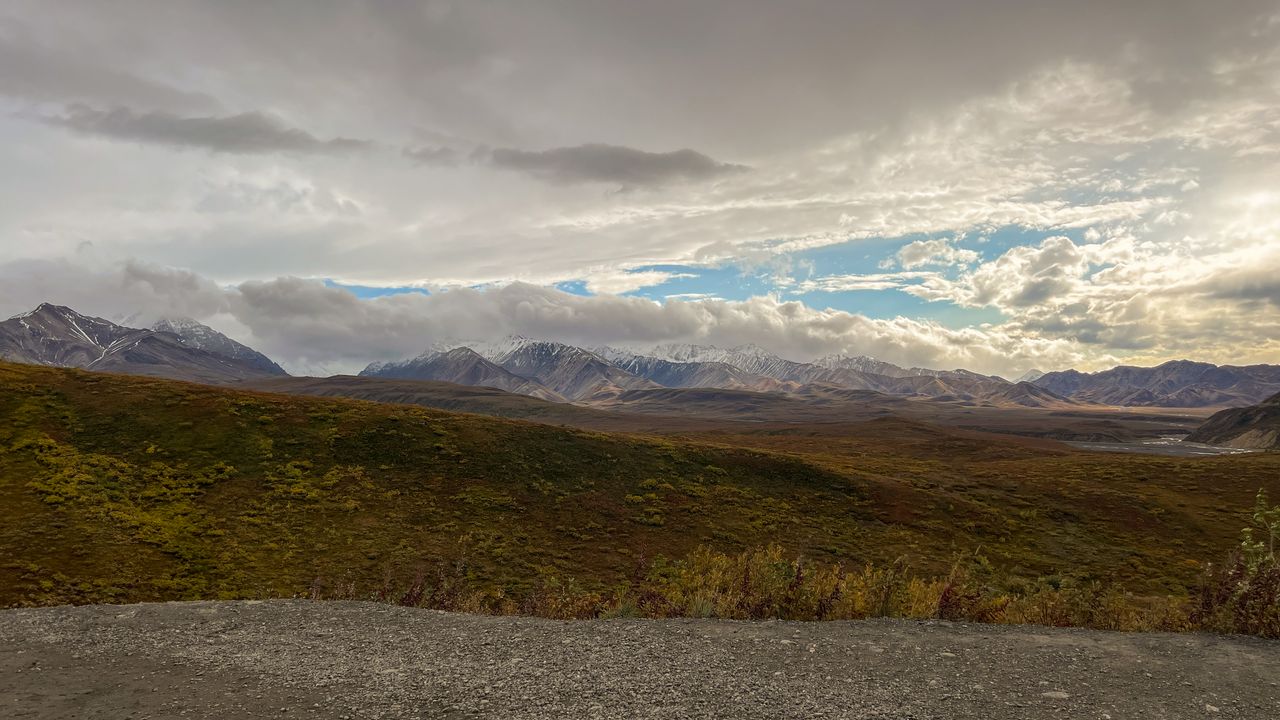
Denali is a genuinely different kind of national park hiking experience than almost anywhere else in the Lower 48 — the park spans roughly 6.1 million acres, about the size of New Hampshire and the third-largest national park in the country, and outside a small cluster of maintained trails near the entrance, there’s essentially no formal trail system at all. Most of Denali is genuine off-trail wilderness where experienced backpackers navigate by terrain and map rather than blazes, which makes the park’s small collection of maintained day hikes near the entrance genuinely valuable: they’re the accessible, low-commitment way to actually experience Denali’s tundra, boreal forest, and mountain views without needing backcountry navigation skills.
There’s also a well-known local saying worth knowing before you even arrive: those who actually see the mountain are part of the “30% club” — roughly 70% of visitors never see Denali itself, since the peak is so frequently shrouded in cloud cover. This genuinely shapes how you should plan a Denali trip, and it’s a thread worth carrying through every hike in this guide.
This guide covers the best day hikes in Denali, from the scenic viewpoints on the drive in through easy lakeside walks and the park’s most rewarding ridgeline climbs — with critical 2026 access information, since a major road closure and a new private vehicle restriction genuinely reshape which trails are reachable this year compared to previous seasons.
For gear appropriate to Alaska’s genuinely variable weather and tundra terrain, our what to wear hiking in summer guide covers layering for conditions that shift fast, and our best hiking boots for men and best hiking boots for women guides cover footwear for the loose gravel and tundra surfaces found throughout the park.
Before You Go — Essential 2026 Planning Information
Private vehicle access is genuinely limited to Mile 15 in 2026, a real change from the park’s typical access pattern. The Park Road stretches an impressive 92 miles into the wilderness — 15 miles of paved two-lane road, 16 miles of two-lane gravel, and 61 miles of rustic single-track gravel beyond that — but private vehicles simply cannot drive past Mile 15 regardless of the season. Beyond that point, the shuttle bus is your only option.
Eielson Visitor Center is closed for the 2026 season due to a road closure at Mile 43, with reopening expected in 2027. This directly affects trail access — the Thorofare Ridge Trail at Eielson, which offers what many experienced Denali hikers consider the finest views of the mountain from any maintained trail in the park, is genuinely inaccessible this year.
The park shuttle bus runs from early June through mid-September, and it’s required to reach trails deeper into the park beyond the Mile 15 private vehicle limit — including the Mountain Vista and Savage Alpine trailheads. Check current shuttle schedules and any reservation requirements before your visit.
Bear country protocols apply throughout the park, including on maintained trails near the entrance. Carry bear spray, know how to use it, and stay alert — grizzly bears, wolves, moose, and caribou are genuinely present throughout Denali’s ecosystem.
Pets are strictly prohibited on Denali’s trails to protect wildlife.
Free dispersed camping exists just outside the park boundary if you’re road-tripping in. A stretch of open pavement roughly 17 miles south of the park entrance, tucked within the spine of the Alaska Range along the Nenana River, is a genuinely popular free RV and car-camping spot for visitors driving up from Anchorage the night before starting their park visit.
On the Way to the Park — Two Viewpoints Worth the Stop
If you’re driving up from Anchorage along the Seward Highway and George Parks Highway, two roadside viewpoints deliver some of the best photography opportunities of the entire trip — and neither is actually inside the park boundary.
Denali Viewpoint South is the first of these stops, with two viewing platforms — the upper platform provides a sweeping view of the Chulitna River alongside the mountain itself. On a clear day, this is genuinely a must-stop for photographers specifically, since Denali towers to 20,310 feet above sea level here with minimal obstruction. Measured from base to summit rather than sea level, Denali actually stands a full mile taller than Everest — a genuinely surprising fact most visitors don’t know before arriving. The mountain’s Koyukon Athabaskan name, Denali, translates to “the tall one,” a fitting name that predates the mountain’s former designation as Mount McKinley.
Denali Viewpoint North sits about 28 miles further up the highway, roughly a half-hour drive from the southern viewpoint, and delivers another sweeping panorama of the Alaska Range. This stop is also where the region’s dramatic geology becomes visible directly in the landscape — the Alaska Range formed through a slow-motion collision as the Pacific Plate slides beneath the North American Plate, carrying blocks of crust called terranes that plow into and fuse onto the continent rather than sliding underneath. Each new terrane crushes into its northern neighbor, and the current actor in that ongoing collision is the Yakutat terrane, still actively colliding with Alaska today — which is part of why this mountain range, the 10th tallest in the world, continues to uplift even now.
Practical tip: Both viewpoints look completely different between winter and summer — if you’ve seen photos of one season, it’s genuinely worth understanding that the same spot in the other season is close to unrecognizable, buried under feet of snow in winter versus fully green and river-fed in summer.
Easy Hikes — Near the Entrance and Savage River Area
Savage River Loop — Best Easy Hike With Ancient Geology
Distance: 2 miles round trip | Elevation gain: Minimal | Difficulty: Easy
This is genuinely one of the most popular and best-trafficked easy trails in the park, and for good reason — it’s fairly level throughout, follows the Savage River with a calm, continuous water sound rather than the sustained climbing effort of the park’s harder trails, and the shuttle drops passengers essentially right at the trailhead. Families and casual walkers consistently choose this trail specifically because it delivers real scenery without demanding real effort.
The genuinely fascinating detail about this specific trail is geological: the Savage River runs through some of the oldest rock formations on the entire North American continent, with this range estimated at somewhere between 600 million and over a billion years old. Hikers who happen to have a geologist along — or who simply know to look — can spot rock formations with a distinctly weathered, “funky” appearance that reflects that immense age and the repeated transformation those rocks have undergone over geologic time.
At the official halfway point, a bridge crosses the river; cross it and you can continue to the right side toward the ranger station and additional restroom facilities, or cross back over to return to your starting point. Either way, this is a genuinely rewarding, low-effort hike that pairs naturally with a more demanding trail the same day.
Practical tip: This trail is accessible by private vehicle within the Mile 15 limit, or via the Savage River Shuttle if you’d rather not deal with parking at this popular trailhead.
Mountain Vista Loop Trail — Best Ultra-Short Option for a Quick Denali View
Distance: Roughly 15-minute loop (under 1 mile) | Elevation gain: Minimal | Difficulty: Easy
Don’t underestimate this trail simply because of its short length — multiple bus drivers and park staff specifically point visitors here for one of the best chances at a mountain view for the lowest possible effort in the entire park. The trailhead sits at the Mountain Vista parking lot, conveniently the same lot where many visitors leave their car before boarding a shuttle to the Savage Alpine trailhead, making this a natural add-on at the end of a longer hiking day.
Visitors who’ve hiked the full Savage Alpine Trail earlier in the day and come back to a suddenly clear sky have found this short loop delivers a genuinely excellent, unobstructed mountain view — sometimes better than what they saw from the alpine trail itself, purely because the clouds finally cleared later in the day. Don’t skip this trail simply because it looks minor on a map; the combination of minimal effort and genuine payoff makes it one of the best value hikes in the park.
Moderate to Strenuous Hikes
Mount Healy Overlook Trail — Best Steep Climb for Denali Views
Distance: 5.4 miles round trip | Elevation gain: Roughly 1,700 feet | Difficulty: Moderate to Strenuous
The Mount Healy Overlook Trail is a genuine steep climb that rewards sustained effort with sweeping views of the entire Denali National Park entrance area — and on a clear, fortunate day, a view of Denali itself looming roughly 80 miles away. The trail ascends through alpine meadows and spruce forest, with the panorama genuinely unfolding progressively as you climb.
Practical tip: This is accessible via the Taiga Trail connector from the Visitor Center parking lot, making it one of the more logistically simple strenuous hikes in the park despite requiring genuine sustained climbing effort.
Savage Alpine Trail — Best Hike Accessible in 2026, and the Park’s Signature Wildlife Hike
Distance: Roughly 4 miles one-way (up to 8 miles round trip if not shuttled) | Elevation gain: Roughly 1,250-1,500 feet | Difficulty: Strenuous
With Eielson Visitor Center closed for the 2026 season, the Savage Alpine Trail becomes genuinely the best hike accessible this year — reachable via the Mountain Vista parking lot and shuttle, delivering sweeping views of the Alaska Range and, on clear days, Denali itself. The trail’s terrain shifts noticeably as you climb: starting green with trees near the bottom, transitioning into brush and dense bushes at mid-elevation, and finally opening into genuine tundra covered in lichen as you approach the higher sections, with some light rock scrambling required near the top. The landscape changes almost continuously with elevation, and the views improve the entire way up rather than delivering everything at once from a single overlook.
This is also, genuinely, one of the best wildlife-viewing trails in the entire park. Arctic ground squirrels are abundant along the upper sections — visitors consistently spot dozens of them darting between rocks near the tundra zone. Dall sheep are a real highlight specifically on this trail: distinctive pure-white, long-legged sheep with smaller horns than visitors often expect, frequently visible resting on rocky slopes close enough to the trail that hikers can observe them at a comfortable, respectful distance without the animals appearing bothered by foot traffic. Mountain goats are also a genuine possibility in the same general area.
Partway up, keep an eye out for a quartz vein visible directly in the rock — a genuinely interesting geological feature formed when hot mineral-laden water intrudes into igneous rock as it’s forming deep underground, depositing minerals that create these visible veins running through the surrounding stone.
On weather and patience: This trail is a genuinely strong illustration of the “30% club” reality mentioned earlier — hikers have reported reaching a rest stop with Denali “so close to coming out,” waiting close to an hour hoping the clouds at the summit would clear, then deciding to continue rather than wait indefinitely, only to round a corner further down the trail and suddenly see the full peak clear of clouds. The lesson genuinely worth taking from this: don’t fixate on waiting at one single spot for the mountain to appear. Keep moving, since nearly anywhere in the park offers a chance at the view if the clouds do eventually break.
Practical tip: Given this trail’s elevated importance in 2026 due to the Eielson closure, expect real crowds on clear days specifically. Take breaks as needed on the roughly 1,250 feet of sustained elevation gain — most hikers report this being genuinely manageable with a reasonable pace and regular rest stops, rather than a technically difficult climb.
Triple Lakes Trail — Best Moderate Hike With a Suspension Bridge
Distance: 0.75 miles one-way to the suspension bridge (roughly 1.5 miles round trip); up to 9.5 miles for the full trail | Elevation gain: Modest to the bridge; the full trail is genuinely strenuous | Difficulty: Moderate for the bridge segment; Strenuous for the full trail
The short version of this trail — hiking just to the suspension bridge over the Nenana River, built by the park’s own sled dogs — is a genuinely accessible option starting downhill from the Visitor Center, with a fork partway where hikers choose between a steeper 25% grade descent or a gentler, slightly longer route at roughly an 8% climb for the return trip. Reaching just the bridge takes most hikers under 30 minutes each way without rushing.
Practical tip: This trail sees genuine regular foot traffic, but stays meaningfully quieter than the immediate Visitor Center area.
Connector Trails
Taiga Trail — Best Trail Network Hub
Distance: 0.9-mile loop, functions primarily as a connector | Elevation gain: Minimal | Difficulty: Easy
The Taiga Trail connects the Visitor Center to Rock Creek Trail, Mount Healy Overlook Trail, and Horseshoe Lake Trail, winding through genuine boreal forest — pine, spruce, and larch. Wildlife sightings including moose and bears are genuinely possible along this relatively flat trail.
Building Your Denali Itinerary
One day: Savage River Loop in the morning for an easy, geologically fascinating introduction, followed by Mountain Vista Loop later in the day specifically to catch the mountain if the clouds have cleared by then.
Two to three days: Day one covers the drive-in viewpoints (Denali Viewpoint South and North) if you’re arriving from Anchorage, plus the free dispersed camping spot near Mile 17. Day two tackles the Savage Alpine Trail as the signature wildlife and geology hike, finishing with Mountain Vista Loop at the trailhead parking lot. Day three covers Mount Healy Overlook for a genuine strenuous climb, or the full Triple Lakes Trail for hikers who want the longest maintained frontcountry option.
Four or more days: Build in real flexibility around weather — Denali’s mountain visibility is famously a matter of luck, and multiple hiking days meaningfully improve your odds of joining the 30% club who actually see the peak clear of clouds.
Final Thoughts
Denali rewards visitors who understand two things going in: the park’s own trail system is intentionally small relative to its 6.1-million-acre scale, and the mountain itself is genuinely a matter of luck rather than guaranteed scenery. Start with the drive-in viewpoints and Savage River Loop to understand the region’s geology at an easy pace, add the Savage Alpine Trail for the park’s best combination of wildlife, geology, and mountain views, and don’t skip the short Mountain Vista Loop at the end of a hiking day — sometimes the clouds clear late, and that 15-minute trail delivers the payoff a much longer hike didn’t.
Carry bear spray on every hike in this guide without exception, and if you don’t see Denali on your first attempt, keep moving rather than waiting in one spot — the mountain has a way of appearing exactly when you’ve stopped expecting it.
For more national park hiking guides, check our best hikes in Olympic National Park and best hikes in Glacier National Park guides.